IMAGES TAKEN NEAR TO
Horsecroft Road, EDGWARE, HA8 0PD
Introduction
This page details the photographs taken nearby to Horsecroft Road, HA8 0PD by members of the Geograph project.
The Geograph project started in 2005 with the aim of publishing, organising and preserving representative images for every square kilometre of Great Britain, Ireland and the Isle of Man.

There are currently over 7.5m images from over14,400 individuals and you can help contribute to the project by visiting https://www.geograph.org.uk
Image Map (Loading...)


Getting Data...Please wait
Leaflet Map data © OpenStreetMap
Images are licensed for reuse under creativecommons.org/licenses/by-sa/2.0
Notes
- Clicking on the map will re-center to the selected point.
- The higher the marker number, the further away the image location is from the centre of the postcode.
Image Listing (9 Images Found)
Images are licensed for reuse under creativecommons.org/licenses/by-sa/2.0
Image
Details
Distance
2
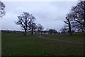
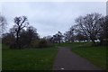
Towards Cressingham Road
Looking across Watling Park.
Image: © DS Pugh
Taken: 31 Dec 2018
0.16 miles
3
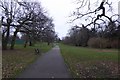
Path leading to Watling Avenue
A path leading across Watling Park.
Image: © DS Pugh
Taken: 31 Dec 2018
0.22 miles
4
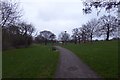
Path to Deansbrook Road
Looking along a path in Watling Park.
Image: © DS Pugh
Taken: 31 Dec 2018
0.23 miles
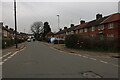
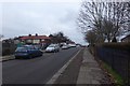
5
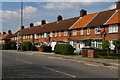
Burnt Oak: houses on Deansbrook Road
Image: © Christopher Hilton
Taken: 19 Apr 2017
0.23 miles
7
Path junctions in Watling Park
Looking along a path in Watling Park towards a choice of other paths.
Image: © DS Pugh
Taken: 31 Dec 2018
0.24 miles
8
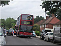
Abbots Road
Looking along the road beside Watling Park.
Image: © DS Pugh
Taken: 31 Dec 2018
0.25 miles
9
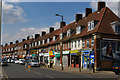
Burnt Oak: parade of shops on Deansbrook Road
Image: © Christopher Hilton
Taken: 19 Apr 2017
0.25 miles