IMAGES TAKEN NEAR TO
Gaskarth Road, EDGWARE, HA8 0DG
Introduction
This page details the photographs taken nearby to Gaskarth Road, HA8 0DG by members of the Geograph project.
The Geograph project started in 2005 with the aim of publishing, organising and preserving representative images for every square kilometre of Great Britain, Ireland and the Isle of Man.

There are currently over 7.5m images from over14,400 individuals and you can help contribute to the project by visiting https://www.geograph.org.uk
Image Map
Images are licensed for reuse under creativecommons.org/licenses/by-sa/2.0
Notes
- Clicking on the map will re-center to the selected point.
- The higher the marker number, the further away the image location is from the centre of the postcode.
Image Listing (74 Images Found)
Images are licensed for reuse under creativecommons.org/licenses/by-sa/2.0
Image
Details
Distance
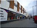
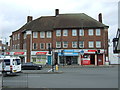
2

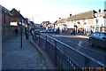
Watling Avenue
Looking up the hill towards the A5 from the bottom of the Silk Stream valley.
Image: © Martin Addison
Taken: 25 Feb 2011
0.07 miles
5
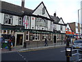
The Bald Faced Stag public house, Burnt Oak
Image: © Stacey Harris
Taken: 27 Nov 2010
0.07 miles
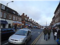
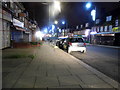
6
Burnt Oak: Watling Avenue
Viewed looking south westwards from Burnt Oak Tube Station.
Image: © Nigel Cox
Taken: 17 Dec 2005
0.08 miles
8
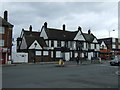
The Bald Faced Stag public house, Burnt Oak
Image: © JThomas
Taken: 18 Mar 2017
0.09 miles
9
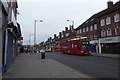
Bus on Watling Avenue
A 302 bus for Kensal Rise on Watling Avenue.
Image: © DS Pugh
Taken: 31 Dec 2018
0.09 miles
10
Watling Post Office
On Burnt Oak Broadway.
Image: © JThomas
Taken: 18 Mar 2017
0.09 miles