IMAGES TAKEN NEAR TO
Barnfield Road, EDGWARE, HA8 0AZ
Introduction
This page details the photographs taken nearby to Barnfield Road, HA8 0AZ by members of the Geograph project.
The Geograph project started in 2005 with the aim of publishing, organising and preserving representative images for every square kilometre of Great Britain, Ireland and the Isle of Man.

There are currently over 7.5m images from over14,400 individuals and you can help contribute to the project by visiting https://www.geograph.org.uk
Image Map
Images are licensed for reuse under creativecommons.org/licenses/by-sa/2.0
Notes
- Clicking on the map will re-center to the selected point.
- The higher the marker number, the further away the image location is from the centre of the postcode.
Image Listing (68 Images Found)
Images are licensed for reuse under creativecommons.org/licenses/by-sa/2.0
Image
Details
Distance
1
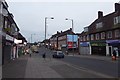
Watling Avenue
Approaching its junction with Barnfield Road.
Image: © DS Pugh
Taken: 31 Dec 2018
0.03 miles
2
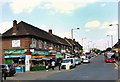
Watling Avenue, Burnt Oak
Cooks from many nations are catered for in the food shops along here.
The origins of the name Burnt Oak are uncertain, but the simplest theory seems the most likely. When this area was first built on following the completion of the railway to Edgware, the first estate was on a plot of land called Burnt Oak Field.
Image: © Des Blenkinsopp
Taken: 17 Jul 2013
0.04 miles
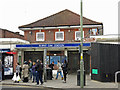
3

Watling Avenue
Parade of shops leading up to Burnt Oak station.
Image: © Martin Addison
Taken: 25 Feb 2011
0.04 miles
4
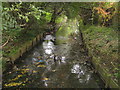
Silk Stream in Burnt Oak
Uploading this Image reminded me of this image and illustrates the point made in the caption to the other photograph. The Silk Stream is viewed here looking downstream from the south side of the shops in Watling Avenue.
Image: © Nigel Cox
Taken: 17 Oct 2006
0.04 miles
6
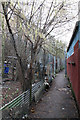
Alley Behind The Shops
At the Watling Avenue end of the footpath from Deansbrook Road, the path is sandwiched between the rear of the shops on Watling Avenue itself and buildings associated with the market in Burnt Oak station car park.
Access to Watling Avenue is up a ramp and a stairway through the buildings - the ram is just visible to the left of centre. The stairs are clearly used as a convenient toilet by some members of the public and reek of urine.
Image: © Martin Addison
Taken: 25 Feb 2011
0.06 miles
7
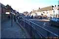
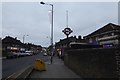
Burnt Oak: Watling Avenue
Viewed looking south westwards from Burnt Oak Tube Station.
Image: © Nigel Cox
Taken: 17 Dec 2005
0.06 miles
8
Burnt Oak tube station - entrance building
The station was designed by architect Stanley Heaps, the head of the Underground's Architects Office, and opened as Burnt Oak (Watling) in 1924 as part of the extension of the Hampstead & Highgate Line from Hendon Central to Edgware https://en.wikipedia.org/wiki/Burnt_Oak_tube_station .
Image: © Mike Quinn
Taken: 3 Oct 2018
0.06 miles
9
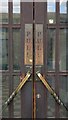
Burnt Oak tube station - entrance doors
The doors can be seen in Image
Image: © Mike Quinn
Taken: 3 Oct 2018
0.06 miles
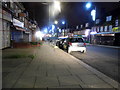
10
Burnt Oak tube station
Looking along Watling Avenue towards the tube station entrance.
Image: © DS Pugh
Taken: 31 Dec 2018
0.07 miles