IMAGES TAKEN NEAR TO
Burnt Oak Broadway, EDGWARE, HA8 0AX
Introduction
This page details the photographs taken nearby to Burnt Oak Broadway, HA8 0AX by members of the Geograph project.
The Geograph project started in 2005 with the aim of publishing, organising and preserving representative images for every square kilometre of Great Britain, Ireland and the Isle of Man.

There are currently over 7.5m images from over14,400 individuals and you can help contribute to the project by visiting https://www.geograph.org.uk
Image Map
Images are licensed for reuse under creativecommons.org/licenses/by-sa/2.0
Notes
- Clicking on the map will re-center to the selected point.
- The higher the marker number, the further away the image location is from the centre of the postcode.
Image Listing (69 Images Found)
Images are licensed for reuse under creativecommons.org/licenses/by-sa/2.0
Image
Details
Distance
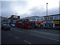
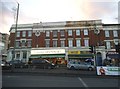
1
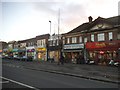
Burnt Oak Broadway
The remainder of the shops are in Watling Street which is the busiest part and where the station is.
Image: © David Howard
Taken: 7 Jan 2016
0.03 miles
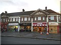
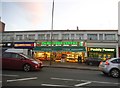
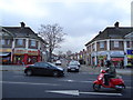
9
Shops on Burnt Oak Broadway
Another major shopping centre which has removed all its free parking and probably sent more people to the large off-road centres.
Image: © David Howard
Taken: 7 Jan 2016
0.08 miles
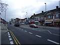
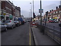
10
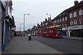
Bus on Watling Avenue
A 302 bus for Kensal Rise on Watling Avenue.
Image: © DS Pugh
Taken: 31 Dec 2018
0.08 miles