IMAGES TAKEN NEAR TO
Pangbourne Drive, STANMORE, HA7 4RA
Introduction
This page details the photographs taken nearby to Pangbourne Drive, HA7 4RA by members of the Geograph project.
The Geograph project started in 2005 with the aim of publishing, organising and preserving representative images for every square kilometre of Great Britain, Ireland and the Isle of Man.

There are currently over 7.5m images from over14,400 individuals and you can help contribute to the project by visiting https://www.geograph.org.uk
Image Map
Images are licensed for reuse under creativecommons.org/licenses/by-sa/2.0
Notes
- Clicking on the map will re-center to the selected point.
- The higher the marker number, the further away the image location is from the centre of the postcode.
Image Listing (7 Images Found)
Images are licensed for reuse under creativecommons.org/licenses/by-sa/2.0
Image
Details
Distance
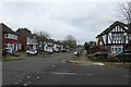
2
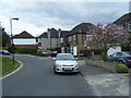
Along Pangbourne Drive
Approaching the junction with Dalkeith Grove.
Image: © DS Pugh
Taken: 31 Dec 2018
0.10 miles
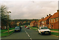
3
Stanmore: Dalkeith Grove
The 1940s Ordnance Survey mapping shows this whole area as a golf course. The road is viewed looking north eastwards with Lake Grove Recreation Ground beyond the railings on the right.
Image: © Nigel Cox
Taken: 17 Dec 2005
0.11 miles
4
Morecambe Gardens, Stanmore 1994
Stanmore Common can be seen rising behind the houses.
Image: © David Howard
Taken: Unknown
0.13 miles
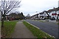
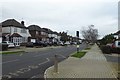
5
Pangbourne Drive
Looking along Pangbourne Drive from Jesmond Way.
Image: © DS Pugh
Taken: 31 Dec 2018
0.17 miles
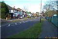
6
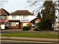
Watling Medical Centre, Stanmore Branch
42 London Road Stanmore HA7 4NU
Image: © Oxyman
Taken: 27 Mar 2011
0.23 miles
7
Dalkeith Grove
Looking along Dalkeith Grove near the bridge over the Jubilee Line.
Image: © DS Pugh
Taken: 31 Dec 2018
0.24 miles