IMAGES TAKEN NEAR TO
Copley Road, STANMORE, HA7 4PF
Introduction
This page details the photographs taken nearby to Copley Road, HA7 4PF by members of the Geograph project.
The Geograph project started in 2005 with the aim of publishing, organising and preserving representative images for every square kilometre of Great Britain, Ireland and the Isle of Man.

There are currently over 7.5m images from over14,400 individuals and you can help contribute to the project by visiting https://www.geograph.org.uk
Image Map
Images are licensed for reuse under creativecommons.org/licenses/by-sa/2.0
Notes
- Clicking on the map will re-center to the selected point.
- The higher the marker number, the further away the image location is from the centre of the postcode.
Image Listing (106 Images Found)
Images are licensed for reuse under creativecommons.org/licenses/by-sa/2.0
Image
Details
Distance
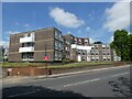
6
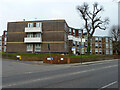
Flats, Rusper Close, Stanmore
This block actually faces London Road.
Image: © Robin Webster
Taken: 23 Feb 2013
0.09 miles
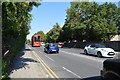
9
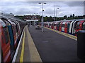
Looking north from Stanmore Station platform
The end of the line and station building can be seen at the end. Obviously both trains are only going in one direction.
Image: © David Howard
Taken: 16 Jul 2008
0.11 miles
10
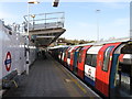
Stanmore station - platform 3
Northern end of the Jubilee line (formerly the Bakerloo).
Image: © Peter Whatley
Taken: 1 Apr 2012
0.11 miles