IMAGES TAKEN NEAR TO
Church Road, STANMORE, HA7 4FD
Introduction
This page details the photographs taken nearby to Church Road, HA7 4FD by members of the Geograph project.
The Geograph project started in 2005 with the aim of publishing, organising and preserving representative images for every square kilometre of Great Britain, Ireland and the Isle of Man.

There are currently over 7.5m images from over14,400 individuals and you can help contribute to the project by visiting https://www.geograph.org.uk
Image Map
Images are licensed for reuse under creativecommons.org/licenses/by-sa/2.0
Notes
- Clicking on the map will re-center to the selected point.
- The higher the marker number, the further away the image location is from the centre of the postcode.
Image Listing (106 Images Found)
Images are licensed for reuse under creativecommons.org/licenses/by-sa/2.0
Image
Details
Distance
1

Direction Sign - Signpost on the A410 in Stanmore
Nipple finial - 2 arms; Middlesex CC iron by the A410, in parish of Stanmore (Harrow District), on the southwest side of the T junction of the A410 Uxbridge Road and Old Church Lane.
Surveyed
Milestone Society National ID: MX_TQ1692
Image: © C Woodward
Taken: 5 Mar 2003
0.03 miles
2
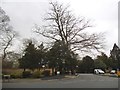
Uxbridge Road at the junction of Old Church Lane
Image: © David Howard
Taken: 13 Apr 2018
0.04 miles
4
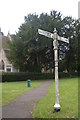
Pre-Worboys direction sign outside the parish church, Stanmore
Image: © Christopher Hilton
Taken: 22 Sep 2016
0.05 miles
5
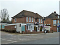
Crazy London pub, Stanmore, 2013
Starting out as the Crown, it went through several name changes. This was its last before demolition.
Image: © Robin Webster
Taken: 23 Feb 2013
0.05 miles
6
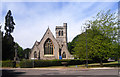
St John the Evangelist, Stanmore
Unsurprisingly there is already a fair selection of pictures from several contributors of the old parish church, (out of sight behind from this angle)
After all it is ruined and romantic and altogether very photogenic.
But this is the replacement, a pleasant enough Victorian church, opened in 1851, but one which hasn't featured on Geograph till now.
Image: © Des Blenkinsopp
Taken: 25 May 2011
0.05 miles
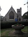
7

St John the Evangelist, Rectory Lane, Stanmore
At the junction with Church Road
Image: © Robin Sones
Taken: 17 Sep 2014
0.05 miles
8
St John the Evangelist, Old Church Lane, Stanmore
Image: © Robin Sones
Taken: 17 Sep 2014
0.05 miles
9
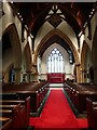
Interior of St John the Evangelist Church, Stanmore
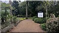
There are two churches in Stanmore Churchyard. The old one was consecrated in 1632 by Archbishop Laud. This is the interior of the new church of St John the Evangelist, which was begun in 1849 and contains much of the furnishings of the old church - see https://www.geograph.org.uk/photo/4736968
There are plans, which can be seen in the new church, to restore the old church, reroof it and make it into a community space. A very full account of both churches can be seen at https://www.stanmoretouristboard.org.uk/churches/st-johns-brick-church-ruin-stanmore.html
Image: © Marathon
Taken: 11 Apr 2022
0.05 miles
10
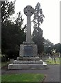
War memorial, St John's Church, Rectory Lane, Stanmore
Image: © Robin Sones
Taken: 17 Sep 2014
0.06 miles