IMAGES TAKEN NEAR TO
Merrion Avenue, STANMORE, HA7 4BS
Introduction
This page details the photographs taken nearby to Merrion Avenue, HA7 4BS by members of the Geograph project.
The Geograph project started in 2005 with the aim of publishing, organising and preserving representative images for every square kilometre of Great Britain, Ireland and the Isle of Man.

There are currently over 7.5m images from over14,400 individuals and you can help contribute to the project by visiting https://www.geograph.org.uk
Image Map
Images are licensed for reuse under creativecommons.org/licenses/by-sa/2.0
Notes
- Clicking on the map will re-center to the selected point.
- The higher the marker number, the further away the image location is from the centre of the postcode.
Image Listing (86 Images Found)
Images are licensed for reuse under creativecommons.org/licenses/by-sa/2.0
Image
Details
Distance
1
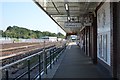
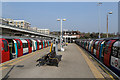
Stanmore Underground station
The branch between Wembley Park and Stanmore was opened by the Metropolitan Railway on the 10th December 1932. It was much harder to construct than anticipated and amongst the heavy works was the diversion of the Wealdstone Brook. It became part of the Bakerloo Line in 1939 when that line was extended from Baker Street to Finchley Road, from there taking over the Metropolitan's old slow tracks to Wembley Park before the Bakerloo continued to Stanmore. In 1979 it became part of the Jubilee Line to Charing Cross, and in 1999 was linked to Stratford by the Jubilee Line Extension.
This view looks back towards the station building on London Road.
Image: © Marathon
Taken: 11 Nov 2015
0.02 miles
2
Stanmore Underground station
The branch between Wembley Park and Stanmore was opened by the Metropolitan Railway on the 10th December 1932. It was much harder to construct than anticipated and amongst the heavy works was the diversion of the Wealdstone Brook. It became part of the Bakerloo Line in 1939 when that line was extended from Baker Street to Finchley Road, from there taking over the Metropolitan's old slow tracks to Wembley Park before the Bakerloo continued to Stanmore. In 1979 it became part of the Jubilee Line to Charing Cross, and in 1999 was linked to Stratford by the Jubilee Line Extension.
This view looks back towards the station building on London Road.
Image: © Marathon
Taken: 11 Nov 2015
0.02 miles
3
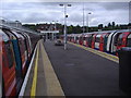
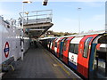
Looking north from Stanmore Station platform
The end of the line and station building can be seen at the end. Obviously both trains are only going in one direction.
Image: © David Howard
Taken: 16 Jul 2008
0.02 miles
4
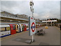
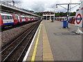
Stanmore Station
Jubilee Line trains of Alstom built 1996 stock stand in platforms 1 & 2 of the station.
Image: © Martin Addison
Taken: 8 Apr 2015
0.02 miles
6
Stanmore Underground station, Greater London
Opened in 1932 by the Metropolitan Railway as the terminus of what is now the Jubilee line from Central London.
View north west towards the buffers. Like 55% of the London Underground network, this part is actually overground.
Image: © Nigel Thompson
Taken: 14 Sep 2018
0.02 miles
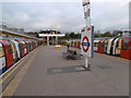
7
Stanmore station - platform 3
Northern end of the Jubilee line (formerly the Bakerloo).
Image: © Peter Whatley
Taken: 1 Apr 2012
0.03 miles
8
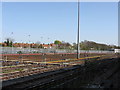
Stanmore carriage sidings
Even on a Sunday afternoon, no stock is at idle.
Image: © Peter Whatley
Taken: 1 Apr 2012
0.03 miles
9
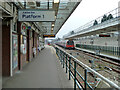
Platform 1, Stanmore station
The terminus of the Jubilee Line.
Image: © Robin Webster
Taken: 23 Feb 2013
0.03 miles