1
Houses on September Way, Stanmore
A turning off Old Church Lane, on the site of Stanmore LNWR station.
Image: © Robin Webster
Taken: 23 Feb 2013
0.14 miles
2
Stanmore: Former Stanmore Village railway station
This was a not entirely successful effort to replicate the esteemed Dr Neil Clifton's
Image The ground floor window openings of the house, the doorway and the square stone opening to the right are just about the only recognisable remains of the front façade of the former station building.
Image: © Nigel Cox
Taken: 3 Jul 2011
0.15 miles
3
Stanmore Telephone Exchange, Middlesex
Located at 17 Elm Park, this building used to be a Manual TE until the mid-1960s, and had GRImsdyke numbers until the late 1960s. It now has 0208 - 954 xxxx numbers, and its postcode is HA7 4AX.
Image: © David Hillas
Taken: 2 Jun 2016
0.15 miles
4
Stanmore Village railway station (site), Greater London
Opened in 1890 by the London & North Western Railway as the terminus of its short branch line from Harrow & Wealdstone, this station closed to passengers in 1952 and completely in 1964.
View south east at the forecourt. Originally the building was designed to look like a village church with a tower on the left hand side, and has been much altered - only the lower windows and door are recognisable in old photographs. The platform was end-on to the right of the building.
For more information, see http://www.disused-stations.org.uk/s/stanmore_village/index.shtml.
Image: © Nigel Thompson
Taken: 14 Sep 2018
0.15 miles
5
Blue Butterfly Montessori, Gordon Avenue
Image: © Bryn Holmes
Taken: 18 Oct 2023
0.15 miles
6
House on corner of Gordon Avenue and Old Church Lane
Looking possibly disused here, it seems to be in the grounds of a modern care home just down Gordon Avenue. It is possible the care home was built in the grounds of this house.
Image: © Robin Webster
Taken: 23 Feb 2013
0.15 miles
7
Stanmore: Former Stanmore Village railway station now September Way
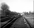
This was another attempt to take a photograph from the same viewpoint occupied by the esteemed Dr Neil Clifton in 1957
Image All traces of the railway have now gone from here, but the trees beyond the houses could be in the same locations as the trees on the left of the railway in the earlier photograph.
The railway functioned from 1890 to 1964 although passenger traffic was terminated in 1952. The trackwork and sidings had all been lifted by 1970 when the current September Way housing estate was started.
Image: © Nigel Cox
Taken: 3 Jul 2011
0.16 miles
8
Gordon Avenue, east end
Image: © Christopher Hilton
Taken: 22 Sep 2016
0.16 miles
9
Stanmore Village station, Middlesex
This station has already been closed to passengers for many years by the time of this 1957 photograph, but it saw an occasional goods train. By the end of 1964, however, this too had gone and the station was abandoned.
Image: © Dr Neil Clifton
Taken: 16 Feb 1957
0.16 miles
10
Stanmore Chapel, Marsh Lane
There was a nursery class playing in the forecourt hence the angle. At the junction with Nelson Road
Image: © Robin Sones
Taken: 17 Sep 2014
0.17 miles


