IMAGES TAKEN NEAR TO
Algar Close, STANMORE, HA7 3NL
Introduction
This page details the photographs taken nearby to Algar Close, HA7 3NL by members of the Geograph project.
The Geograph project started in 2005 with the aim of publishing, organising and preserving representative images for every square kilometre of Great Britain, Ireland and the Isle of Man.

There are currently over 7.5m images from over14,400 individuals and you can help contribute to the project by visiting https://www.geograph.org.uk
Image Map
Images are licensed for reuse under creativecommons.org/licenses/by-sa/2.0
Notes
- Clicking on the map will re-center to the selected point.
- The higher the marker number, the further away the image location is from the centre of the postcode.
Image Listing (28 Images Found)
Images are licensed for reuse under creativecommons.org/licenses/by-sa/2.0
Image
Details
Distance
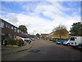
6

Transformer on Masefield Avenue, Stanmore
Image: © David Howard
Taken: 4 Sep 2014
0.15 miles
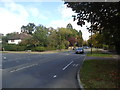
7

Edgware Brook, Stanmore
Edgware Brook as it runs downstream from Summerhouse Lake through the Bentley Priory Open Space towards the residential areas of Stanmore.
Image: © Nigel Cox
Taken: 27 Nov 2005
0.15 miles
9
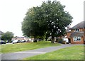
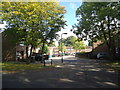
Avenue of trees on Stilwell Drive, Stanmore
Image: © David Howard
Taken: 4 Sep 2014
0.16 miles
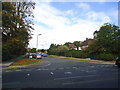
10
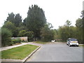
Masefield Avenue at the entrance to Bentley Priory
Image: © David Howard
Taken: 4 Sep 2014
0.16 miles