IMAGES TAKEN NEAR TO
Aylmer Drive, STANMORE, HA7 3EJ
Introduction
This page details the photographs taken nearby to Aylmer Drive, HA7 3EJ by members of the Geograph project.
The Geograph project started in 2005 with the aim of publishing, organising and preserving representative images for every square kilometre of Great Britain, Ireland and the Isle of Man.

There are currently over 7.5m images from over14,400 individuals and you can help contribute to the project by visiting https://www.geograph.org.uk
Image Map
Images are licensed for reuse under creativecommons.org/licenses/by-sa/2.0
Notes
- Clicking on the map will re-center to the selected point.
- The higher the marker number, the further away the image location is from the centre of the postcode.
Image Listing (37 Images Found)
Images are licensed for reuse under creativecommons.org/licenses/by-sa/2.0
Image
Details
Distance
1
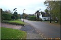
Stanmore: Aylmer Drive
Exclusive housing estate, viewed looking south westwards.
Image: © Nigel Cox
Taken: 27 Nov 2005
0.05 miles
3
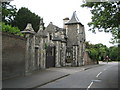
Stanmore: Lodge and gate piers to Stanmore Hall
Stanmore Hall was originally built in the 1840s and is now private residential accommodation. These are the contemporary Grade II Listed entrance lodge and gate piers to the hall on Wood Lane. With its swept pyramid-style roof the lodge and the gate piers are constructed of rubble with ashlar dressings. Surmounting the gate piers are two heraldic beasts.
Image: © Nigel Cox
Taken: 5 Jun 2011
0.15 miles
5
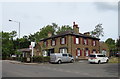
The former Vine public house, Stanmore
Now converted into luxury apartments.
Image: © JThomas
Taken: 3 Aug 2019
0.16 miles
6
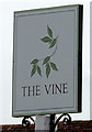
Sign for the former Vine public house, Stanmore
Image: © JThomas
Taken: 3 Aug 2019
0.17 miles
7
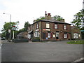
Stanmore: The former Vine public house now the Raw Lasan
The Vine was at the top of Stanmore Hill but has now been converted into an Indian and Indo-Chinese Fusion Restaurant http://rawlasan.com/index.html. Lasan is Gujarati for garlic, so the photographer understands.
The original Vine pub sign, bearing the name Sedgwicks, is still in situ on the left. The only obvious cross reference to Sedgwicks that the photographer can find is that there was a Sedgwicks family brewery based in Watford, that functioned from 1862 to 1923 when the brewery was taken over by Benskins.
Image: © Nigel Cox
Taken: 5 Jun 2011
0.17 miles
9
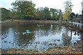
Stanmore: Spring Pond, Little Common
A lot of the trees around the pond have recently been removed to eliminate an algae infestation. Viewed looking eastwards with Wood Lane on the right, this pond is one of four on Stanmore Hill.
Image: © Nigel Cox
Taken: 27 Nov 2005
0.18 miles
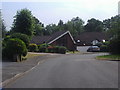
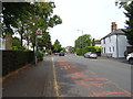
10
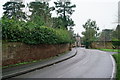
Stanmore
Wood Lane, looking towards the junction with the A4140.
Image: © Peter Trimming
Taken: 24 Jan 2020
0.18 miles