IMAGES TAKEN NEAR TO
Green Lane, STANMORE, HA7 3AH
Introduction
This page details the photographs taken nearby to Green Lane, HA7 3AH by members of the Geograph project.
The Geograph project started in 2005 with the aim of publishing, organising and preserving representative images for every square kilometre of Great Britain, Ireland and the Isle of Man.

There are currently over 7.5m images from over14,400 individuals and you can help contribute to the project by visiting https://www.geograph.org.uk
Image Map
Images are licensed for reuse under creativecommons.org/licenses/by-sa/2.0
Notes
- Clicking on the map will re-center to the selected point.
- The higher the marker number, the further away the image location is from the centre of the postcode.
Image Listing (111 Images Found)
Images are licensed for reuse under creativecommons.org/licenses/by-sa/2.0
Image
Details
Distance
1
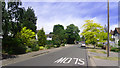
Green Lane, Stanmore
Some Suburban Sunshine.
And it is reasonably green, isn't it.
Image: © Des Blenkinsopp
Taken: 25 May 2011
0.05 miles
2
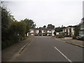
Bowls Close, Stanmore
An archetypal development of 1960s small houses.
Image: © David Howard
Taken: 4 Sep 2014
0.07 miles
3
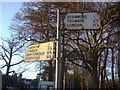
Pre-Worboys signs on the corner of Uxbridge Road and Clamp Hill
These are the other side of the pair, in better condition than the others.
Image: © David Howard
Taken: 26 Dec 2008
0.08 miles
4
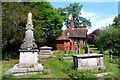
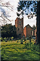
St. Johns Churchyard, Stanmore
Old tombs and a cottage on the north side of the churchyard.
Image: © Des Blenkinsopp
Taken: 25 May 2011
0.09 miles
5
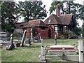
Gatehouse, St John's Churchyard, Uxbridge Road, Stanmore
Image: © Robin Sones
Taken: 17 Sep 2014
0.09 miles
6
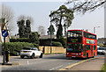
Uxbridge Road
A 340 bus on route to Harrow Bus Station from Edgware Station passes along the A410 in Stanmore.
Image: © Martin Addison
Taken: 8 Apr 2015
0.09 miles
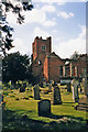
9
St John's Church, Stanmore
There has been a church on this site since the 6th century. This church, known as "the Brick Church" was in use from 1632 - 1850 when the present church came into use.
http://www.stjohnsstanmore.org.uk/content.php?folder_id=9
Image: © Christine Matthews
Taken: Unknown
0.10 miles
10
St John's Church, Stanmore
There has been a church on this site since the 6th century. This church, known as the brick church, was in use from 1632 - 1850, when it was replaced by the present church.
http://www.stjohnsstanmore.org.uk/content.php?folder_id=9
Image: © Christine Matthews
Taken: Unknown
0.10 miles