IMAGES TAKEN NEAR TO
Green Verges, STANMORE, HA7 2SN
Introduction
This page details the photographs taken nearby to Green Verges, HA7 2SN by members of the Geograph project.
The Geograph project started in 2005 with the aim of publishing, organising and preserving representative images for every square kilometre of Great Britain, Ireland and the Isle of Man.

There are currently over 7.5m images from over14,400 individuals and you can help contribute to the project by visiting https://www.geograph.org.uk
Image Map
Images are licensed for reuse under creativecommons.org/licenses/by-sa/2.0
Notes
- Clicking on the map will re-center to the selected point.
- The higher the marker number, the further away the image location is from the centre of the postcode.
Image Listing (41 Images Found)
Images are licensed for reuse under creativecommons.org/licenses/by-sa/2.0
Image
Details
Distance
3
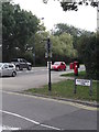
Derelict buildings, Marsh Lane
Not the most salubrious of views to welcome visitors!
Image: © Nigel Thompson
Taken: 14 Sep 2018
0.05 miles

6
Street sign, Old Church Lane, Stanmore
At the junction with Marsh Lane
Image: © Robin Sones
Taken: 17 Sep 2014
0.07 miles
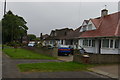
10
Wildcroft Gardens, Stanmore
At the junction with Marsh Lane
Image: © Robin Sones
Taken: 17 Sep 2014
0.12 miles