IMAGES TAKEN NEAR TO
Hermitage Way, STANMORE, HA7 2AX
Introduction
This page details the photographs taken nearby to Hermitage Way, HA7 2AX by members of the Geograph project.
The Geograph project started in 2005 with the aim of publishing, organising and preserving representative images for every square kilometre of Great Britain, Ireland and the Isle of Man.

There are currently over 7.5m images from over14,400 individuals and you can help contribute to the project by visiting https://www.geograph.org.uk
Image Map (54 Images)


Leaflet Map data © OpenStreetMap
Images are licensed for reuse under creativecommons.org/licenses/by-sa/2.0
Notes
- Clicking on the map will re-center to the selected point.
- The higher the marker number, the further away the image location is from the centre of the postcode.
Image Listing (54 Images Found)
Images are licensed for reuse under creativecommons.org/licenses/by-sa/2.0
Image
Details
Distance
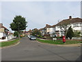
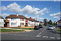
2
Beverley Gardens crosses Curzon Avenue
Image: © Des Blenkinsopp
Taken: 4 Sep 2019
0.10 miles
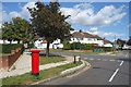
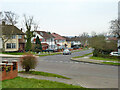
3
S Edmunds Drive, Belmont
Junction with Beverley Gardens.
1930s residential streets, like all this area.
Image: © Des Blenkinsopp
Taken: 4 Sep 2019
0.12 miles
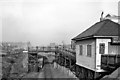
4
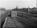
Belmont, Middlesex
Looking northwards along the track towards Stanmore Village. This section still saw an occasional goods train at the time of the photograph.
Image: © Dr Neil Clifton
Taken: 16 Feb 1957
0.13 miles
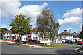
6
Top end of Beverley Gardens, Stanmore
Image: © Robin Webster
Taken: 23 Feb 2013
0.13 miles
7
Belmont (Middlesex) Station
View northward, towards Stanmore; Harrow & Wealdstone - Stanmore branch, closed Belmont - Stanmore (Village) 15/9/52 (goods 6/7/64); Belmont station (only opened 12/9/32) was closed 5/10/64 when line from Harrow was closed (completely).
Image: © Ben Brooksbank
Taken: 19 Feb 1961
0.14 miles
8
Belmont: Site of former railway station
This is taken from the same location on Kenton Lane as Ben's Image although with the closure of the railway the bridge must have been lowered. Just about the only common feature is the line of houses just visible through the trees to the left. Although the London & North Western Railway opened their line to Stanmore through here in 1890, Belmont's station was not built until 1932. In fact it only lasted for twenty years and three days before being closed to passenger traffic in 1952. The line lingered on with occasional freight trains to Stanmore but closed completely in 1964.
Image: © Nigel Cox
Taken: 1 Dec 2010
0.14 miles
9
Harrow: Trackbed of the dismantled railway, Belmont
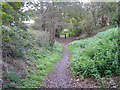
Dismantled railway lines are normally associated with rural locations, but this one is in London. This branch line ran from Harrow and Wealdstone railway station to Stanmore with one intermediate station, at Belmont, and was originally financed by a wealthy landowner who owned Stanmore Golf Club and other land in the area. The railway was closed in 1964, a victim of Dr. Beeching's cuts. One of the possible factors in its downfall was the geometry of the connection at Harrow and Wealdstone where trains from Stanmore ended up facing northwards away from London. This view was taken looking southwards at the point where the railway crossed the east end of Vernon Drive.
Image: © Nigel Cox
Taken: 12 Nov 2005
0.14 miles
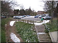
10
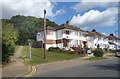
Vernon Drive, Belmont
The start of the footpath over Belmont Hill.
Image: © Des Blenkinsopp
Taken: 4 Sep 2019
0.15 miles