IMAGES TAKEN NEAR TO
Crowshott Avenue, STANMORE, HA7 1HP
Introduction
This page details the photographs taken nearby to Crowshott Avenue, HA7 1HP by members of the Geograph project.
The Geograph project started in 2005 with the aim of publishing, organising and preserving representative images for every square kilometre of Great Britain, Ireland and the Isle of Man.

There are currently over 7.5m images from over14,400 individuals and you can help contribute to the project by visiting https://www.geograph.org.uk
Image Map
Images are licensed for reuse under creativecommons.org/licenses/by-sa/2.0
Notes
- Clicking on the map will re-center to the selected point.
- The higher the marker number, the further away the image location is from the centre of the postcode.
Image Listing (35 Images Found)
Images are licensed for reuse under creativecommons.org/licenses/by-sa/2.0
Image
Details
Distance
1
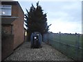
Transformer on Crowshott Avenue, Little Stanmore
Image: © David Howard
Taken: 12 Nov 2015
0.02 miles
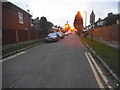
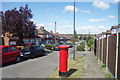
3
Crowshott Avenue, Stanmore
Corner with Pickett Croft, a short cul de sac.
Image: © Des Blenkinsopp
Taken: 4 Sep 2019
0.06 miles
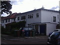
4
Anmersh Grove, Little Stanmore
There was a large tree just by the lamp post, you can just see the stump, it was there last year.
Image: © David Howard
Taken: 12 Nov 2015
0.08 miles
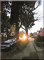
6

Trees on Crowshott Avenue, Little Stanmore
Image: © David Howard
Taken: 12 Nov 2015
0.10 miles
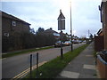
7
Lamorna Grove
A suburban valley, Lamorna Grove slopes gently down towards the now culverted Edgware Brook.
Image: © Des Blenkinsopp
Taken: 4 Sep 2019
0.13 miles
9
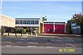
Stanmore Fire Station, Honeypot Lane, Stanmore
Built in 1960, the design of Stanmore Fire Station is typical of many outer London suburban fire stations. The top of the drill tower is just visible over the roof.
Image: © Nigel Cox
Taken: 30 Oct 2003
0.13 miles
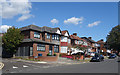
10
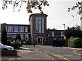
Park High School, Stanmore
The tower faces along Thistlecroft Gardens. Opened as Chandos School in 1939, it was a secondary modern under the Education Act 1944 until Harrow went comprehensive in the 1970s. The original buildings remain a good example of the mildly modernist work of the Middlesex County Council architects W T Curtis (county architect 1930-46) and H W Burchett (assistant architect for educational buildings).
Image: © Chris Brown
Taken: 30 Aug 2018
0.16 miles