IMAGES TAKEN NEAR TO
Unwin Way, STANMORE, HA7 1FG
Introduction
This page details the photographs taken nearby to Unwin Way, HA7 1FG by members of the Geograph project.
The Geograph project started in 2005 with the aim of publishing, organising and preserving representative images for every square kilometre of Great Britain, Ireland and the Isle of Man.

There are currently over 7.5m images from over14,400 individuals and you can help contribute to the project by visiting https://www.geograph.org.uk
Image Map (Loading...)


Getting Data...Please wait
Leaflet Map data © OpenStreetMap
Images are licensed for reuse under creativecommons.org/licenses/by-sa/2.0
Notes
- Clicking on the map will re-center to the selected point.
- The higher the marker number, the further away the image location is from the centre of the postcode.
Image Listing (90 Images Found)
Images are licensed for reuse under creativecommons.org/licenses/by-sa/2.0
Image
Details
Distance
1
Bramble Close, Canons Park
From the junction with Honeypot Lane
Image: © Robin Sones
Taken: 17 Sep 2014
0.06 miles
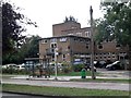
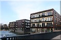
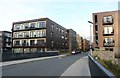
3
Fountains and apartments, Howard Road, Canons Park
Image: © Robin Sones
Taken: 17 Sep 2014
0.06 miles
6
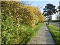
Alongside Honeypot Lane
This is looking in the direction of Queensbury.
Image: © Marathon
Taken: 28 Oct 2015
0.08 miles
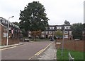
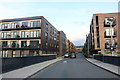
7
Howard Road, Canons Park
This is a recently built estate. Some greenery would brighten it up.
Image: © David Howard
Taken: 17 Feb 2019
0.08 miles
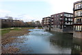
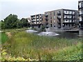
8
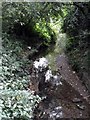
Deans Brook, Whitchurch Lane, Canons Park
Image: © Robin Sones
Taken: 17 Sep 2014
0.08 miles
9
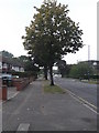
Whitchurch Lane, Canons Park
Looking to the junction with Longcrofte Road
Image: © Robin Sones
Taken: 17 Sep 2014
0.09 miles