IMAGES TAKEN NEAR TO
Honeypot Lane, STANMORE, HA7 1ET
Introduction
This page details the photographs taken nearby to Honeypot Lane, HA7 1ET by members of the Geograph project.
The Geograph project started in 2005 with the aim of publishing, organising and preserving representative images for every square kilometre of Great Britain, Ireland and the Isle of Man.

There are currently over 7.5m images from over14,400 individuals and you can help contribute to the project by visiting https://www.geograph.org.uk
Image Map (Loading...)


Getting Data...Please wait
Leaflet Map data © OpenStreetMap
Images are licensed for reuse under creativecommons.org/licenses/by-sa/2.0
Notes
- Clicking on the map will re-center to the selected point.
- The higher the marker number, the further away the image location is from the centre of the postcode.
Image Listing (40 Images Found)
Images are licensed for reuse under creativecommons.org/licenses/by-sa/2.0
Image
Details
Distance
1
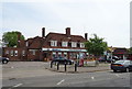
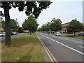
Indian restaurant on Honeypot Lane (A4140)
Also known as the Honeypot.
Image: © JThomas
Taken: 3 Aug 2019
0.03 miles

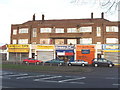
8
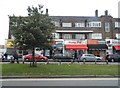
Sathy Estates on Honeypot Lane, Queensbury
Image: © David Howard
Taken: 8 Oct 2015
0.13 miles
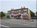
10

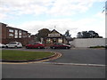
Old garage on corner of Cumberland Road, Queensbury
This used to be a petrol station
Image: © David Howard
Taken: 6 Nov 2008
0.16 miles