IMAGES TAKEN NEAR TO
Elgood Avenue, NORTHWOOD, HA6 3QS
Introduction
This page details the photographs taken nearby to Elgood Avenue, HA6 3QS by members of the Geograph project.
The Geograph project started in 2005 with the aim of publishing, organising and preserving representative images for every square kilometre of Great Britain, Ireland and the Isle of Man.

There are currently over 7.5m images from over14,400 individuals and you can help contribute to the project by visiting https://www.geograph.org.uk
Image Map
Images are licensed for reuse under creativecommons.org/licenses/by-sa/2.0
Notes
- Clicking on the map will re-center to the selected point.
- The higher the marker number, the further away the image location is from the centre of the postcode.
Image Listing (13 Images Found)
Images are licensed for reuse under creativecommons.org/licenses/by-sa/2.0
Image
Details
Distance
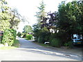
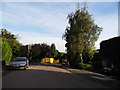
1
Northwood: Elgood Avenue
Viewed looking westwards.
Image: © Nigel Cox
Taken: 20 Nov 2005
0.08 miles
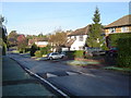
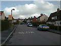
2
Gate End at the junction of Gatehill Road, Northwood
Image: © David Howard
Taken: 6 Sep 2012
0.09 miles
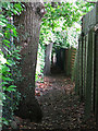
4
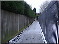
Public footpath from Northwood Way to Addison Way
Hillside school is behind the railings on the right.
Image: © David Howard
Taken: 4 Feb 2009
0.21 miles
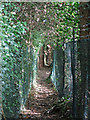
6

Width restriction on the footpath north of Gatehill Road
Not for the gravitationally challenged.
Image: © Mike Quinn
Taken: 9 Oct 2019
0.23 miles
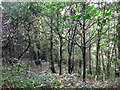
8
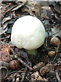
Mushroom and acorns by the footpath north of Gatehill Road
Image: © Mike Quinn
Taken: 9 Oct 2019
0.23 miles