IMAGES TAKEN NEAR TO
Sandy Lane, NORTHWOOD, HA6 3ES
Introduction
This page details the photographs taken nearby to Sandy Lane, HA6 3ES by members of the Geograph project.
The Geograph project started in 2005 with the aim of publishing, organising and preserving representative images for every square kilometre of Great Britain, Ireland and the Isle of Man.

There are currently over 7.5m images from over14,400 individuals and you can help contribute to the project by visiting https://www.geograph.org.uk
Image Map
Images are licensed for reuse under creativecommons.org/licenses/by-sa/2.0
Notes
- Clicking on the map will re-center to the selected point.
- The higher the marker number, the further away the image location is from the centre of the postcode.
Image Listing (28 Images Found)
Images are licensed for reuse under creativecommons.org/licenses/by-sa/2.0
Image
Details
Distance
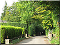
2
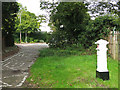
Woodside Walk
The wood is Oxhey Wood, ahead. A covered reservoir is on the right.
Image: © Robin Webster
Taken: 23 Feb 2013
0.10 miles
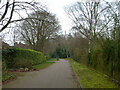
3
Long, straight footpath south of Seven Acres
Image: © Mike Quinn
Taken: 9 Oct 2019
0.13 miles
5
Potter Street Hill
Just south of its junction with Sandy Lane and Oxhey Drive South. Shows the location of Image
Image: © Mike Quinn
Taken: 9 Oct 2019
0.15 miles
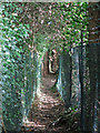
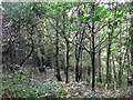
6

Mushroom and acorns by the footpath north of Gatehill Road
Image: © Mike Quinn
Taken: 9 Oct 2019
0.15 miles
9
Potter Street Hill / South View Road
Shows the location of Image (partly obscured by a bollard, lower left).
Image: © Mike Quinn
Taken: 9 Oct 2019
0.16 miles
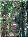
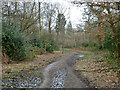
10

Width restriction on the footpath north of Gatehill Road
Not for the gravitationally challenged.
Image: © Mike Quinn
Taken: 9 Oct 2019
0.16 miles