IMAGES TAKEN NEAR TO
Lowswood Close, NORTHWOOD, HA6 2XE
Introduction
This page details the photographs taken nearby to Lowswood Close, HA6 2XE by members of the Geograph project.
The Geograph project started in 2005 with the aim of publishing, organising and preserving representative images for every square kilometre of Great Britain, Ireland and the Isle of Man.

There are currently over 7.5m images from over14,400 individuals and you can help contribute to the project by visiting https://www.geograph.org.uk
Image Map (Loading...)


Getting Data...Please wait
Leaflet Map data © OpenStreetMap
Images are licensed for reuse under creativecommons.org/licenses/by-sa/2.0
Notes
- Clicking on the map will re-center to the selected point.
- The higher the marker number, the further away the image location is from the centre of the postcode.
Image Listing (6 Images Found)
Images are licensed for reuse under creativecommons.org/licenses/by-sa/2.0
Image
Details
Distance
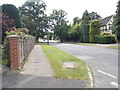
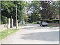
2
Rodgers Ruff at the junction of Links Way
Image: © David Howard
Taken: 17 Jul 2014
0.11 miles
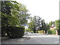
3
Junction of The Broadwalk with Linksway, Northwood
The houses are on Linksway.
Image: © Robin Webster
Taken: 1 Feb 2015
0.12 miles
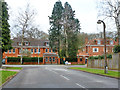
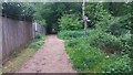
5
The end of Links Way, Northwood
Leading to Copse Wood
Image: © David Howard
Taken: 17 Jul 2014
0.14 miles
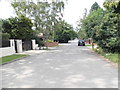
6
Bridleway towards Northwood Golf Club
Bridleway towards Northwood golf club passing the path to The Broadwalk and Copse Wood
Image: © Shaun Ferguson
Taken: 17 May 2019
0.17 miles