IMAGES TAKEN NEAR TO
Old Gannon Close, NORTHWOOD, HA6 2LU
Introduction
This page details the photographs taken nearby to Old Gannon Close, HA6 2LU by members of the Geograph project.
The Geograph project started in 2005 with the aim of publishing, organising and preserving representative images for every square kilometre of Great Britain, Ireland and the Isle of Man.

There are currently over 7.5m images from over14,400 individuals and you can help contribute to the project by visiting https://www.geograph.org.uk
Image Map
Images are licensed for reuse under creativecommons.org/licenses/by-sa/2.0
Notes
- Clicking on the map will re-center to the selected point.
- The higher the marker number, the further away the image location is from the centre of the postcode.
Image Listing (30 Images Found)
Images are licensed for reuse under creativecommons.org/licenses/by-sa/2.0
Image
Details
Distance
3
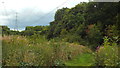
London Loop path near Northwood
The London Loop path heads off to the right of the image.
Image: © Malc McDonald
Taken: 8 Sep 2013
0.12 miles
4
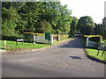
CCTV with number plate recognition, Moor Park
As I entered this housing estate a panel below the camera told me the number of my car.
Image: © David Hawgood
Taken: 3 Feb 2006
0.12 miles
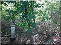
5
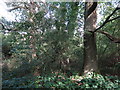
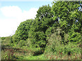
Dense woodland south of Batchworth Lane (4)
Shows the location of Image
Image: © Mike Quinn
Taken: 9 Oct 2019
0.13 miles
6
Dense woodland south of Batchworth Lane (3)
Shows the location of Image
Image: © Mike Quinn
Taken: 9 Oct 2019
0.13 miles
7
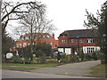
Houses in Astons Road, Moor Park, Northwood
An area of large detached houses.
Image: © David Hawgood
Taken: 3 Feb 2006
0.13 miles
8

Astons Road, Moor Park, Northwood
This building is "Dutch Lodge".
Image: © David Hawgood
Taken: 3 Feb 2006
0.13 miles
9
Dense woodland south of Batchworth Lane (2)
Shows the location of Image
Image: © Mike Quinn
Taken: 9 Oct 2019
0.13 miles
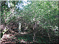
10
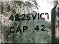
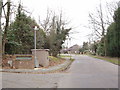
Coal tax boundary post no.54, west of Kewferry Road (detail) (2)
See Image and Image Here, two of the fixing holes for the correction plate can be seen, one by the "C" of "VICT" in the first line of the inscription, and the other below and to the left of the "C" of "CAP" in the second line.
Image: © Mike Quinn
Taken: 9 Oct 2019
0.13 miles