IMAGES TAKEN NEAR TO
Maxwell Road, NORTHWOOD, HA6 2GN
Introduction
This page details the photographs taken nearby to Maxwell Road, HA6 2GN by members of the Geograph project.
The Geograph project started in 2005 with the aim of publishing, organising and preserving representative images for every square kilometre of Great Britain, Ireland and the Isle of Man.

There are currently over 7.5m images from over14,400 individuals and you can help contribute to the project by visiting https://www.geograph.org.uk
Image Map
Images are licensed for reuse under creativecommons.org/licenses/by-sa/2.0
Notes
- Clicking on the map will re-center to the selected point.
- The higher the marker number, the further away the image location is from the centre of the postcode.
Image Listing (127 Images Found)
Images are licensed for reuse under creativecommons.org/licenses/by-sa/2.0
Image
Details
Distance


7
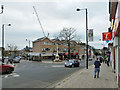
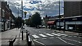
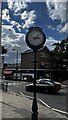
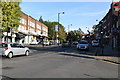
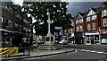
Northwood, by the war memorial
A place largely a result of the building of the Metropolitan Railway. The population increased by a factor of ten in twenty years spanning the opening of the railway here in 1887.
Image: © Robin Webster
Taken: 25 Jan 2015
0.02 miles
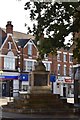
9
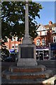
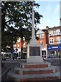
Northwood War Memorial
Grade II listed. https://historicengland.org.uk/listing/the-list/list-entry/1444974
Image: © N Chadwick
Taken: 27 Oct 2019
0.02 miles