IMAGES TAKEN NEAR TO
Myrtleside Close, NORTHWOOD, HA6 2GB
Introduction
This page details the photographs taken nearby to Myrtleside Close, HA6 2GB by members of the Geograph project.
The Geograph project started in 2005 with the aim of publishing, organising and preserving representative images for every square kilometre of Great Britain, Ireland and the Isle of Man.

There are currently over 7.5m images from over14,400 individuals and you can help contribute to the project by visiting https://www.geograph.org.uk
Image Map
Images are licensed for reuse under creativecommons.org/licenses/by-sa/2.0
Notes
- Clicking on the map will re-center to the selected point.
- The higher the marker number, the further away the image location is from the centre of the postcode.
Image Listing (27 Images Found)
Images are licensed for reuse under creativecommons.org/licenses/by-sa/2.0
Image
Details
Distance
1
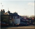
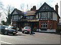
Rickmansworth Road, Northwood
Looking towards the Belair Restaurant, still open in 2017
Image: © David Howard
Taken: Unknown
0.05 miles
5
True Lovers Knot Public House
Now burnt down
Image: © pearl gardner
Taken: Unknown
0.12 miles
6
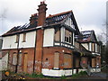
Northwood: The former True Lovers Knot Public House
Activists from CAMRA (The Campaign for Real Ale) are currently warning that almost five pubs in London are permanently closed each week. This is the burnt out shell of the former True Lovers Knot PH on Rickmansworth Road. The London Borough of Hillingdon's Tourism website has a photo of the pub in its heyday here http://www.hillingdon.gov.uk/general/travel/photo_library/detail.php?pic=125
Update March 2008: The pub has now been demolished and the land is now a construction site.
Image: © Nigel Cox
Taken: 23 Mar 2007
0.12 miles
9
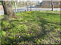
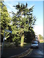
Daffodils on the edge of Northwood Gravel Pits
Wood Way.
Before the 20th century the Northwood Gravel Pits were a major source of gravel for mending local roads. The gravel was described as "worked out" in 1898, but the area was saved from development by being designated a public amenity in commemoration of Queen Victoria's Diamond Jubilee of 1897. In 1905 the site was formally conveyed to the Ruislip-Northwood Urban District Council.
Woodland took over but after many years of neglect the site was restored in the early years of the 21st century with the creation of new paths and improving the biodiversity amongst other actions. See https://www.northwoodresidents.co.uk/index.php/northwood-gravel-pits for more detail.
Image: © Marathon
Taken: 21 Mar 2018
0.12 miles
10
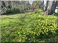
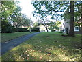
Daffodils at Northwood Gravel Pits
These daffodils are on the corner of Rickmansworth Road and Copse Wood Way.
Before the 20th century the Northwood Gravel Pits were a major source of gravel for mending local roads. The gravel was described as "worked out" in 1898, but the area was saved from development by being designated a public amenity in commemoration of Queen Victoria's Diamond Jubilee of 1897. In 1905 the site was formally conveyed to the Ruislip-Northwood Urban District Council.
Woodland took over but after many years of neglect the site was restored in the early years of the 21st century with the creation of new paths and improving the biodiversity amongst other actions. See https://www.northwoodresidents.co.uk/index.php/northwood-gravel-pits for more detail.
Image: © Marathon
Taken: 21 Mar 2018
0.14 miles