IMAGES TAKEN NEAR TO
Pinner Road, NORTHWOOD, HA6 1QP
Introduction
This page details the photographs taken nearby to Pinner Road, HA6 1QP by members of the Geograph project.
The Geograph project started in 2005 with the aim of publishing, organising and preserving representative images for every square kilometre of Great Britain, Ireland and the Isle of Man.

There are currently over 7.5m images from over14,400 individuals and you can help contribute to the project by visiting https://www.geograph.org.uk
Image Map
Images are licensed for reuse under creativecommons.org/licenses/by-sa/2.0
Notes
- Clicking on the map will re-center to the selected point.
- The higher the marker number, the further away the image location is from the centre of the postcode.
Image Listing (78 Images Found)
Images are licensed for reuse under creativecommons.org/licenses/by-sa/2.0
Image
Details
Distance
1
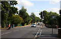
Pinner Road, Northwood Hills
Looking along the A404 towards Pinner from the junction with Briarwood Drive. The fencing on the left conceals a sports ground.
Image: © Martin Addison
Taken: 12 Sep 2009
0.02 miles

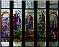
3
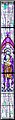
St Edmund the King, Northwood Hills - Window
St John the Baptist
Image: © John Salmon
Taken: 23 May 2004
0.09 miles
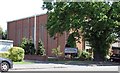
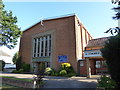
5
St Edmund the King, Northwood Hills - Church Hall
Image: © John Salmon
Taken: 23 May 2004
0.09 miles
6
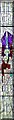
St Edmund the King, Northwood Hills - Window
St Raphael
Image: © John Salmon
Taken: 23 May 2004
0.09 miles
7
St Edmund the King, Northwood Hills - Window
Image: © John Salmon
Taken: 23 May 2004
0.09 miles
8
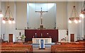
St Edmund the King, Northwood Hills - East end
Image: © John Salmon
Taken: 23 May 2004
0.09 miles
9
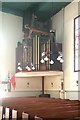
St Edmund the King, Northwood Hills - Organ
Image: © John Salmon
Taken: 23 May 2004
0.09 miles
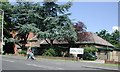
10
St Edmund King and Martyr, Northwood Hills
Image: © Basher Eyre
Taken: 12 Aug 2016
0.09 miles