IMAGES TAKEN NEAR TO
The Broadway, Joel Street, NORTHWOOD, HA6 1NZ
Introduction
This page details the photographs taken nearby to The Broadway, Joel Street, HA6 1NZ by members of the Geograph project.
The Geograph project started in 2005 with the aim of publishing, organising and preserving representative images for every square kilometre of Great Britain, Ireland and the Isle of Man.

There are currently over 7.5m images from over14,400 individuals and you can help contribute to the project by visiting https://www.geograph.org.uk
Image Map
Images are licensed for reuse under creativecommons.org/licenses/by-sa/2.0
Notes
- Clicking on the map will re-center to the selected point.
- The higher the marker number, the further away the image location is from the centre of the postcode.
Image Listing (83 Images Found)
Images are licensed for reuse under creativecommons.org/licenses/by-sa/2.0
Image
Details
Distance
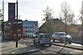
1
Northwood Hills: Joel Street crosses the railway
The London Underground's Metropolitan Line passes under Joel Street, with the station entrance right on top of the bridge.
Image: © Chris Downer
Taken: 10 Jan 2011
0.01 miles
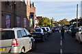
5
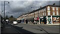
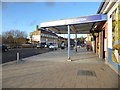
Northwood Hills: shops on Joel Street
One of a few elegant shopping parades to both the north and the south of the railway station, which is immediately behind us.
Image: © Chris Downer
Taken: 10 Jan 2011
0.03 miles
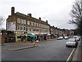
6

The William Jolle public house, Northwood Hills
Image: © Stacey Harris
Taken: 18 Sep 2013
0.03 miles
7
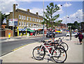
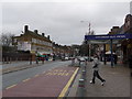
Outside Northwood Hills Station (N)
Looking north along Joel Street.
Image: © Des Blenkinsopp
Taken: 28 Jun 2014
0.04 miles
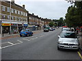
8
The entrance to Northwood Hills station
The Metropolitan Railway reached Harrow-on-the-Hill station in 1880, and Pinner on 25th May 1885 which remained the terminus of the Metropolitan Railway until 1st September 1887 when the line was further extended to Rickmansworth.
In 1915, the Metroland project was conceived in order to move people out of central London into rural Middlesex. Houses near the stations were built in haste and sold for as little as £400 each. The most ambitious Metropolitan suburb along the 'Extension Line' was between Pinner and Northwood. There were open fields here until 1930 when plans were produced for a completely new suburb. A competition was held through the local press to find a name. A lady from North Harrow won the £5 prize with the name 'Northwood Hills'. Ruislip-Northwood Council was not very impressed as they would have preferred 'Northwood Town'. Boards were erected on the muddy Joel Street announcing the impending new station which opened in December 1933. London Transport had come into existence by then as houses began to creep up the muddy Porridge Pot Hill which was renamed Potter Street to suit suburban tastes. A long parade of shops, including a cinema, was erected. However, the first few residents were not too enamoured of the pioneer life complaining about "the mud of the most adhesive quality outside the station".
What is now the Chiltern Line began as the Great Central Railway on 15th March 1899. The Great Central Railway provided services from Marylebone to destinations such as Rugby, Leicester, Nottingham and Manchester before the Beeching Axe cut them back to Aylesbury. They used the same tracks as the Metropolitan until 1962 when a pair of fast lines was added from Harrow-on-the-Hill to north of Moor Park. These by-pass Northwood Hills station to the south and are used by Chiltern Line trains and fast Metropolitan Line trains.
Image: © Marathon
Taken: 31 Jan 2018
0.04 miles