IMAGES TAKEN NEAR TO
Nower Hill, PINNER, HA5 5QR
Introduction
This page details the photographs taken nearby to Nower Hill, HA5 5QR by members of the Geograph project.
The Geograph project started in 2005 with the aim of publishing, organising and preserving representative images for every square kilometre of Great Britain, Ireland and the Isle of Man.

There are currently over 7.5m images from over14,400 individuals and you can help contribute to the project by visiting https://www.geograph.org.uk
Image Map
Images are licensed for reuse under creativecommons.org/licenses/by-sa/2.0
Notes
- Clicking on the map will re-center to the selected point.
- The higher the marker number, the further away the image location is from the centre of the postcode.
Image Listing (23 Images Found)
Images are licensed for reuse under creativecommons.org/licenses/by-sa/2.0
Image
Details
Distance
1
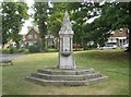
Pinner: The Tooke drinking fountain
The fountain was erected in 1886 by the inhabitants of Pinner in grateful memory of William Arthur Tooke, JP, a local dignitary. It is on a small triangular green at the junction of Church Lane and Moss Lane. With its columns of red granite and with its grey granite broach spire it is a Grade II Listed structure. Unfortunately its drinking fountain capabilites appear to have been lost for some time.
Image: © Nigel Cox
Taken: 5 Jun 2011
0.08 miles
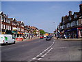
2
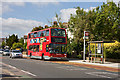
183 Bus on Pinner Road
VLP16 pulls up at the stop for Pinner Cemetery, which is located behind Capel Gardens. The bus is on route from Pinner to Golders Green Station, a lengthy and slow journey with heavy traffic almost always present in Kenton. The vehicle looks like it is due for an overhaul soon.
Image: © Martin Addison
Taken: 12 Sep 2009
0.13 miles
5
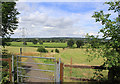
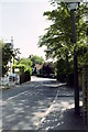
Path from Nower Hill down to Hall's Farm
A much-appreciated open area, with a path leading from the new development on Nower Hill down to George V Avenue and continuing across Hall's Farm, to the footbridge across the railway near Headstone Lane station
Image: © Patrick Wyman
Taken: 3 Aug 2012
0.15 miles
7
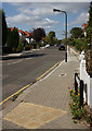
Cecil Park
A quiet suburban street that parallels the Metropolitan Line in Pinner. Seen here from the junction with Marsh Road at its southeast end, it turns abruptly left in the far distance to rejoin Marsh Road by Pinner Library.
Image: © Martin Addison
Taken: 12 Sep 2009
0.16 miles
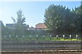
9
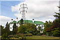
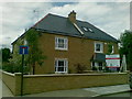
Capel Gardens
Located beside Pinner Road, these are sister apartment blocks to Pinner Court (See Image by Nigel Cox). The trees and pantiled roofs contrast strongly with the 132kV pylon looming behind.
Image: © Martin Addison
Taken: 12 Sep 2009
0.17 miles
10
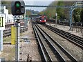
View from the end of the platform at Pinner Underground station
Pinner station was opened on 25th May 1885, following a prior expansion to nearby Harrow-on-the-Hill station in 1880. It remained the terminus of the Metropolitan Railway until 1st September 1887 when the line was further extended to Rickmansworth.
In 1915, the Metroland project was conceived in order to move people out of central London into rural Middlesex. Houses near the stations were built in haste and sold for as little as £400 each. However, in Pinner, houses built during this expansion were required to be worth at least £1,000.
What is now the Chiltern Line began as the Great Central Railway on 15th March 1899. The Great Central Railway provided services from Marylebone to destinations such as Rugby, Leicester, Nottingham and Manchester before the Beeching Axe cut them back to Aylesbury. They used the same tracks as the Metropolitan until 1962 when a pair of fast lines was added from Harrow-on-the-Hill to north of Moor Park. These by-pass Pinner station to the south and are used by Chiltern Line trains and fast Metropolitan Line trains.
In this photograph from the up platform, the fast lines are on the far right. An all-stations Metropolitan line train bound for Chesham approaches. Harrow-on-the-Hill and its church can be seen in the distance.The next station in this direction is North Harrow.
Image: © Marathon
Taken: 27 Apr 2016
0.19 miles