
IMAGES TAKEN NEAR TO
Grange Gardens, PINNER, HA5 5QE
Introduction
This page details the photographs taken nearby to Grange Gardens, HA5 5QE by members of the Geograph project.
The Geograph project started in 2005 with the aim of publishing, organising and preserving representative images for every square kilometre of Great Britain, Ireland and the Isle of Man.

There are currently over 7.5m images from over14,400 individuals and you can help contribute to the project by visiting https://www.geograph.org.uk
Image Map
Images are licensed for reuse under creativecommons.org/licenses/by-sa/2.0
Notes
- Clicking on the map will re-center to the selected point.
- The higher the marker number, the further away the image location is from the centre of the postcode.
Image Listing (138 Images Found)
Images are licensed for reuse under creativecommons.org/licenses/by-sa/2.0
Image
Details
Distance
1
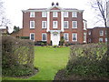
Pinner House
The house is in Church Lane and is possibly 17th century with the façade being completed in 1721. Between 1788 and 1811 it was the home of the Rev. Walter Williams, Vicar of Pinner and Harrow, and his wife, Mary Beauclerc, great-granddaughter of King Charles II and Nell Gwynn.
Image: © Nigel Cox
Taken: 23 Mar 2007
0.04 miles
3
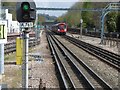
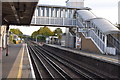
View from the end of the platform at Pinner Underground station
Pinner station was opened on 25th May 1885, following a prior expansion to nearby Harrow-on-the-Hill station in 1880. It remained the terminus of the Metropolitan Railway until 1st September 1887 when the line was further extended to Rickmansworth.
In 1915, the Metroland project was conceived in order to move people out of central London into rural Middlesex. Houses near the stations were built in haste and sold for as little as £400 each. However, in Pinner, houses built during this expansion were required to be worth at least £1,000.
What is now the Chiltern Line began as the Great Central Railway on 15th March 1899. The Great Central Railway provided services from Marylebone to destinations such as Rugby, Leicester, Nottingham and Manchester before the Beeching Axe cut them back to Aylesbury. They used the same tracks as the Metropolitan until 1962 when a pair of fast lines was added from Harrow-on-the-Hill to north of Moor Park. These by-pass Pinner station to the south and are used by Chiltern Line trains and fast Metropolitan Line trains.
In this photograph from the up platform, the fast lines are on the far right. An all-stations Metropolitan line train bound for Chesham approaches. Harrow-on-the-Hill and its church can be seen in the distance.The next station in this direction is North Harrow.
Image: © Marathon
Taken: 27 Apr 2016
0.07 miles
5
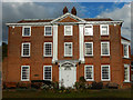
Pinner House
Pinner House on Church Lane has a façade dating from 1721 although the rest of the house was built some time earlier. It is known to have been used as a school for a time in the 19th century but later became a family home. In 1939 it became an old people's home and is now sheltered accommodation for the elderly. There are 31 self-contained flats located in a rear extension to the old house which is now used for communal area and facilities.
Image: © Stephen McKay
Taken: 29 Oct 2018
0.09 miles
6
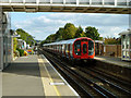
Watford train arriving at Pinner
Composed of S8 stock, that has finally completely replaced A stock on the Metropolitan Line.
Image: © Robin Webster
Taken: 29 Sep 2012
0.09 miles
7
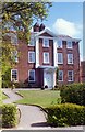
Pinner House
A large Georgian building now used as sheltered housing for the elderly
Image: © Carl Grove
Taken: 12 Apr 1997
0.09 miles
10
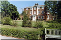
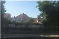
Pinner House
Sheltered housing for the elderly, the facade is a Georgian house at the back of which two modern wings have been added. Situated on Church Lane, in an area with many cases of hauntings.
Image: © Carl Grove
Taken: 22 Aug 1990
0.10 miles