IMAGES TAKEN NEAR TO
Marsh Road, PINNER, HA5 5PA
Introduction
This page details the photographs taken nearby to Marsh Road, HA5 5PA by members of the Geograph project.
The Geograph project started in 2005 with the aim of publishing, organising and preserving representative images for every square kilometre of Great Britain, Ireland and the Isle of Man.

There are currently over 7.5m images from over14,400 individuals and you can help contribute to the project by visiting https://www.geograph.org.uk
Image Map
Images are licensed for reuse under creativecommons.org/licenses/by-sa/2.0
Notes
- Clicking on the map will re-center to the selected point.
- The higher the marker number, the further away the image location is from the centre of the postcode.
Image Listing (75 Images Found)
Images are licensed for reuse under creativecommons.org/licenses/by-sa/2.0
Image
Details
Distance
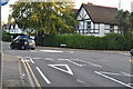
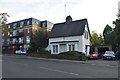
4
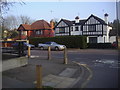
Eastcote Road from junction of Holwell Place
Image: © David Howard
Taken: 8 Mar 2011
0.05 miles
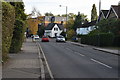
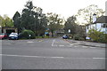
5
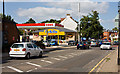
Marsh Road, Pinner
A steady flow of traffic and a busy filling station. The grey mobile phone mast near the centre of the photo dwarfs the lamp posts.
Image: © Martin Addison
Taken: 12 Sep 2009
0.06 miles
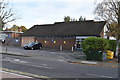
8
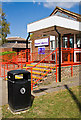
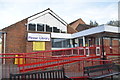
Pinner Library
Located on Marsh Road. The road just visible through the railings is Cecil Park and the building beyond is Pinner Synagogue. Not sure who chose the colour scheme!
Image: © Martin Addison
Taken: 12 Sep 2009
0.07 miles