IMAGES TAKEN NEAR TO
Marsh Road, PINNER, HA5 5NA
Introduction
This page details the photographs taken nearby to Marsh Road, HA5 5NA by members of the Geograph project.
The Geograph project started in 2005 with the aim of publishing, organising and preserving representative images for every square kilometre of Great Britain, Ireland and the Isle of Man.

There are currently over 7.5m images from over14,400 individuals and you can help contribute to the project by visiting https://www.geograph.org.uk
Image Map
Images are licensed for reuse under creativecommons.org/licenses/by-sa/2.0
Notes
- Clicking on the map will re-center to the selected point.
- The higher the marker number, the further away the image location is from the centre of the postcode.
Image Listing (194 Images Found)
Images are licensed for reuse under creativecommons.org/licenses/by-sa/2.0
Image
Details
Distance
2
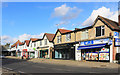
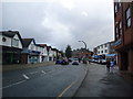
Shops on Marsh Road, Pinner
An off licence, fish & chip shop, a couple of salons, a dentist's and Kevin's Schoolwear.
Image: © Des Blenkinsopp
Taken: 13 Nov 2018
0.01 miles
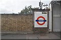
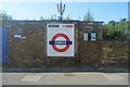
7
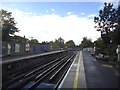
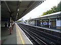
Pinner Underground station
Pinner station was opened on 25th May 1885, following a prior expansion to nearby Harrow-on-the-Hill station in 1880. It remained the terminus of the Metropolitan Railway until 1st September 1887 when the line was further extended to Rickmansworth.
In 1915, the Metroland project was conceived in order to move people out of central London into rural Middlesex. Houses near the stations were built in haste and sold for as little as £400 each. However, in Pinner, houses built during this expansion were required to be worth at least £1,000.
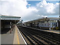
What is now the Chiltern Line began as the Great Central Railway on 15th March 1899. The Great Central Railway provided services from Marylebone to destinations such as Rugby, Leicester, Nottingham and Manchester before the Beeching Axe cut them back to Aylesbury. They used the same tracks as the Metropolitan until 1962 when a pair of fast lines was added from Harrow-on-the-Hill to north of Moor Park. These by-pass Pinner station to the south and are used by Chiltern Line trains and fast Metropolitan Line trains.
In this photograph from the up platform, the fast lines are to the right beyond the down platform. The next station in this direction is North Harrow.
Image: © Marathon
Taken: 27 Apr 2016
0.03 miles
9
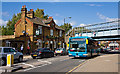
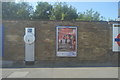
King George IV
A public house on Marsh Road in Pinner next to the Metropolitan Line, with a colourful set of hanging baskets. On the other side of the railway, Marsh Road becomes Bridge Street.
An Arriva the Shires Mercedes-Benz bus approaches on a rail replacement service - the Metropolitan Line was shut all weekend for maintenance work. Normally this vehicle would be working between Watford and Luton Airport.
Image: © Martin Addison
Taken: 12 Sep 2009
0.03 miles