IMAGES TAKEN NEAR TO
Rayners Lane, PINNER, HA5 5HT
Introduction
This page details the photographs taken nearby to Rayners Lane, HA5 5HT by members of the Geograph project.
The Geograph project started in 2005 with the aim of publishing, organising and preserving representative images for every square kilometre of Great Britain, Ireland and the Isle of Man.

There are currently over 7.5m images from over14,400 individuals and you can help contribute to the project by visiting https://www.geograph.org.uk
Image Map (Loading...)


Getting Data...Please wait
Leaflet Map data © OpenStreetMap
Images are licensed for reuse under creativecommons.org/licenses/by-sa/2.0
Notes
- Clicking on the map will re-center to the selected point.
- The higher the marker number, the further away the image location is from the centre of the postcode.
Image Listing (43 Images Found)
Images are licensed for reuse under creativecommons.org/licenses/by-sa/2.0
Image
Details
Distance
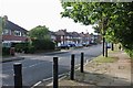
1
Pinner - The Ridgeway from Rayners Lane
Image: © Peter Whatley
Taken: 2 Apr 2012
0.07 miles
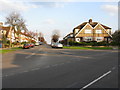
4
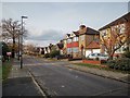
Lincoln Road
Post war semi-detached estate.
Image: © James Emmans
Taken: 20 Nov 2019
0.10 miles


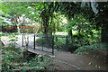
8
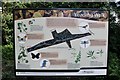
Sign at the entrance to Yeading Walk, Harrow
Image: © David Howard
Taken: 21 May 2020
0.13 miles