IMAGES TAKEN NEAR TO
Central Avenue, PINNER, HA5 5BS
Introduction
This page details the photographs taken nearby to Central Avenue, HA5 5BS by members of the Geograph project.
The Geograph project started in 2005 with the aim of publishing, organising and preserving representative images for every square kilometre of Great Britain, Ireland and the Isle of Man.

There are currently over 7.5m images from over14,400 individuals and you can help contribute to the project by visiting https://www.geograph.org.uk
Image Map
Images are licensed for reuse under creativecommons.org/licenses/by-sa/2.0
Notes
- Clicking on the map will re-center to the selected point.
- The higher the marker number, the further away the image location is from the centre of the postcode.
Image Listing (49 Images Found)
Images are licensed for reuse under creativecommons.org/licenses/by-sa/2.0
Image
Details
Distance
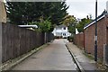
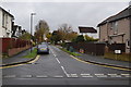
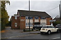
2
The Close, Rayners Lane
The road, from which Rayners Lane Underground station takes its name, runs north from the station to Pinner. It is pleasantly tree-lined and at The Close has small greens on either side of the road.
Image: © Marathon
Taken: 27 Apr 2016
0.10 miles
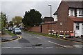
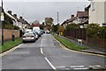
6
Rayners Lane
The road, from which Rayners Lane Underground station takes its name, runs north from the station to Pinner. It is pleasantly tree-lined and at The Close has small greens on either side of the road.
Image: © Marathon
Taken: 27 Apr 2016
0.12 miles
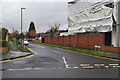
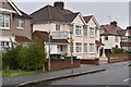
8
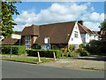
Quaker Meeting House
On Rayners Lane.
Image: © Robin Webster
Taken: 29 Sep 2012
0.13 miles