IMAGES TAKEN NEAR TO
George V Avenue, PINNER, HA5 4SU
Introduction
This page details the photographs taken nearby to George V Avenue, HA5 4SU by members of the Geograph project.
The Geograph project started in 2005 with the aim of publishing, organising and preserving representative images for every square kilometre of Great Britain, Ireland and the Isle of Man.

There are currently over 7.5m images from over14,400 individuals and you can help contribute to the project by visiting https://www.geograph.org.uk
Image Map
Images are licensed for reuse under creativecommons.org/licenses/by-sa/2.0
Notes
- Clicking on the map will re-center to the selected point.
- The higher the marker number, the further away the image location is from the centre of the postcode.
Image Listing (5 Images Found)
Images are licensed for reuse under creativecommons.org/licenses/by-sa/2.0
Image
Details
Distance
1
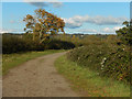
Track across Pinner Park
This track is a public right of way and runs from George V Avenue to Headstone Lane across open countryside still in agricultural use.
Image: © Stephen McKay
Taken: 29 Oct 2018
0.16 miles
2
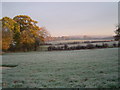
Pinner: Flood storage area
Viewed looking north westwards over frosty fields, this is the flood storage area for the River Pinn upstream of George V Avenue, and upstream of Pinner itself. The River Pinn runs in the trees to the left.
Image: © Nigel Cox
Taken: 30 Nov 2005
0.21 miles
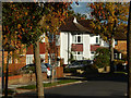
4
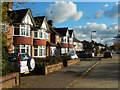
George V Avenue, North Harrow
A pair of classic semi-detached houses, in the mock Tudor style so popular in the inter-war period, stand on the service road of the A404.
Image: © Stephen McKay
Taken: 29 Oct 2018
0.23 miles
5
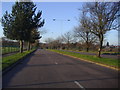
Greystoke Avenue, North Harrow
Semi-detached houses leading off George V Avenue.
Image: © Stephen McKay
Taken: 29 Oct 2018
0.24 miles