IMAGES TAKEN NEAR TO
Gildea Close, PINNER, HA5 4SD
Introduction
This page details the photographs taken nearby to Gildea Close, HA5 4SD by members of the Geograph project.
The Geograph project started in 2005 with the aim of publishing, organising and preserving representative images for every square kilometre of Great Britain, Ireland and the Isle of Man.

There are currently over 7.5m images from over14,400 individuals and you can help contribute to the project by visiting https://www.geograph.org.uk
Image Map
Images are licensed for reuse under creativecommons.org/licenses/by-sa/2.0
Notes
- Clicking on the map will re-center to the selected point.
- The higher the marker number, the further away the image location is from the centre of the postcode.
Image Listing (91 Images Found)
Images are licensed for reuse under creativecommons.org/licenses/by-sa/2.0
Image
Details
Distance
2
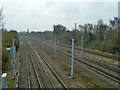
West Coast Main Line
On the London side of Hatch End station.
Image: © Robin Webster
Taken: 23 Feb 2013
0.10 miles
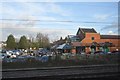
3

Reversing the shot
See Nigel Chadwick's shot of Morrisons taken from the train http://www.geograph.org.uk/photo/2867402
I have taken the train from the superstore!
Image: © Basher Eyre
Taken: 12 Aug 2016
0.10 miles
5
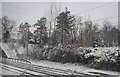
West Coast Main Line south of Hatch End
A snowscene as we pass through Hatch End.
Image: © N Chadwick
Taken: 19 Dec 2010
0.11 miles


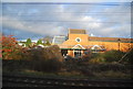
10

Park View at the junction of Anselm Road
Image: © David Howard
Taken: 13 Apr 2018
0.15 miles