IMAGES TAKEN NEAR TO
Sylvia Avenue, PINNER, HA5 4QN
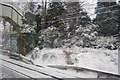
Introduction
This page details the photographs taken nearby to Sylvia Avenue, HA5 4QN by members of the Geograph project.
The Geograph project started in 2005 with the aim of publishing, organising and preserving representative images for every square kilometre of Great Britain, Ireland and the Isle of Man.

There are currently over 7.5m images from over14,400 individuals and you can help contribute to the project by visiting https://www.geograph.org.uk
Image Map
Images are licensed for reuse under creativecommons.org/licenses/by-sa/2.0
Notes
- Clicking on the map will re-center to the selected point.
- The higher the marker number, the further away the image location is from the centre of the postcode.
Image Listing (14 Images Found)
Images are licensed for reuse under creativecommons.org/licenses/by-sa/2.0
Image
Details
Distance
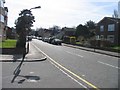
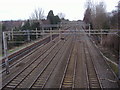
1
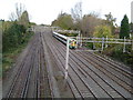
West Coast Main Line railway
Viewed looking northwestwards from the footbridge between The Avenue and Sylvia Avenue north of Hatch End station.
Image: © Nigel Cox
Taken: 12 Nov 2005
0.06 miles
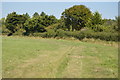
2
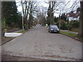
The Avenue, Hatch End
The field behind me was the border with Hertfordshire, with Carpenders Park the north side of it.
Image: © David Howard
Taken: 21 Feb 2008
0.10 miles
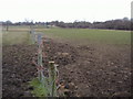
3
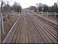
Railway lines looking towards Hatch End
Image: © David Howard
Taken: 21 Feb 2008
0.11 miles
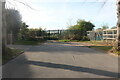
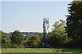
5
Footbridge over the West Coast Main Line, Hatch End
Image: © N Chadwick
Taken: 19 Dec 2010
0.12 miles
6
Railway lines looking to Carpenders Park
Image: © David Howard
Taken: 21 Feb 2008
0.13 miles