IMAGES TAKEN NEAR TO
Grimsdyke Road, PINNER, HA5 4PW
Introduction
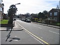
This page details the photographs taken nearby to Grimsdyke Road, HA5 4PW by members of the Geograph project.
The Geograph project started in 2005 with the aim of publishing, organising and preserving representative images for every square kilometre of Great Britain, Ireland and the Isle of Man.

There are currently over 7.5m images from over14,400 individuals and you can help contribute to the project by visiting https://www.geograph.org.uk
Image Map
Images are licensed for reuse under creativecommons.org/licenses/by-sa/2.0
Notes
- Clicking on the map will re-center to the selected point.
- The higher the marker number, the further away the image location is from the centre of the postcode.
Image Listing (48 Images Found)
Images are licensed for reuse under creativecommons.org/licenses/by-sa/2.0
Image
Details
Distance
1
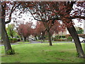
Broadmead Close
Green space in Hatch End.
Image: © Burgess Von Thunen
Taken: 24 Apr 2012
0.08 miles
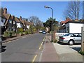
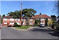
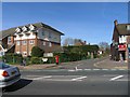
3
Grimsdyke Road, Hatch End
A pleasant residential avenue with the requisite flowering cherries lining the route, but also with these great forest size conifer trees towering above the houses down one side.
Image: © Des Blenkinsopp
Taken: 3 Sep 2012
0.11 miles
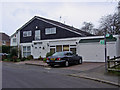
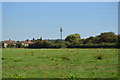
5
Woodridings Close, Hatch End
Cul-de-sac
Image: © John Salmon
Taken: 16 Mar 2007
0.12 miles
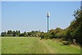
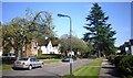
8
From Uxbridge Road towards Woodridings Close, Hatch End, HA5
The block of maisonettes behind the post box on the corner of Woodridings Close have been built on the site of the former Hatch End Library. As a historical note, the library premises were single storey, surrounded by gardens and the site was cleared due to Harrow Council declaring the building to be unsafe for continued public use. The former library was popular and well used in the 1950's and 1960's; replacement premises for the library have been found about three quarters of a mile to the east in the former Royal Commercial Travellers' School site on the south side of Uxbridge Road.
Image: © John Salmon
Taken: 16 Mar 2007
0.14 miles