IMAGES TAKEN NEAR TO
Anselm Road, PINNER, HA5 4LH
Introduction
This page details the photographs taken nearby to Anselm Road, HA5 4LH by members of the Geograph project.
The Geograph project started in 2005 with the aim of publishing, organising and preserving representative images for every square kilometre of Great Britain, Ireland and the Isle of Man.

There are currently over 7.5m images from over14,400 individuals and you can help contribute to the project by visiting https://www.geograph.org.uk
Image Map
Images are licensed for reuse under creativecommons.org/licenses/by-sa/2.0
Notes
- Clicking on the map will re-center to the selected point.
- The higher the marker number, the further away the image location is from the centre of the postcode.
Image Listing (120 Images Found)
Images are licensed for reuse under creativecommons.org/licenses/by-sa/2.0
Image
Details
Distance
1
Helston Close from Cornwall Road, Hatch End
Image: © John Salmon
Taken: 16 Mar 2007
0.07 miles
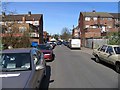
2
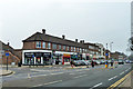
Suburban shops, Hatch End
It was snowing lightly, strangely neither noticeably settling on the ground nor wetting it.
Image: © Robin Webster
Taken: 23 Feb 2013
0.08 miles

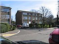
5

Park View at the junction of Anselm Road
Image: © David Howard
Taken: 13 Apr 2018
0.09 miles
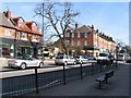
6
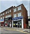
Papu-Miya Pizza Parlour
The Broadway, Hatch End.
Image: © Fernweh
Taken: 31 Aug 2021
0.09 miles

8
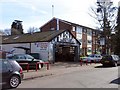
Hatch End Motor Company, Cornwall Road, Hatch End
Image: © John Salmon
Taken: 16 Mar 2007
0.10 miles
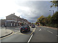
10
Uxbridge Road towards Grimsdyke Road, Hatch End
Image: © John Salmon
Taken: 16 Mar 2007
0.10 miles