IMAGES TAKEN NEAR TO
Station Approach, PINNER, HA5 4HU
Introduction
This page details the photographs taken nearby to Station Approach, HA5 4HU by members of the Geograph project.
The Geograph project started in 2005 with the aim of publishing, organising and preserving representative images for every square kilometre of Great Britain, Ireland and the Isle of Man.

There are currently over 7.5m images from over14,400 individuals and you can help contribute to the project by visiting https://www.geograph.org.uk
Image Map
Images are licensed for reuse under creativecommons.org/licenses/by-sa/2.0
Notes
- Clicking on the map will re-center to the selected point.
- The higher the marker number, the further away the image location is from the centre of the postcode.
Image Listing (100 Images Found)
Images are licensed for reuse under creativecommons.org/licenses/by-sa/2.0
Image
Details
Distance
1
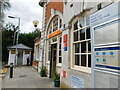
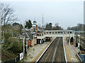
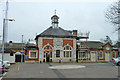
Hatch End railway station
This is the frontage of the Grade II Listed Hatch End railway station, originally built in 1911 for the London & North Western Railway to the designs of the architect Gerald C Horsley. The English Heritage Listed Buildings website describes it thus:-
"Symmetrically composed. Red brick with stone dressings. Two arches to ground-storey with central sashed window and large decorative crest over. Left hand arch has doors with window over. Right hand arch is fully glazed above stone plinth. Channelled pilaster quoins with dentil cornice. Tile roof surmounted by pedimented cupola with inset clock. Single-storey, irregular wings to right and left."
Sir John Betjeman was a great admirer of the station building and famously described it as being "half-way between a bank and a medium sized country house".
Old Victorian Ordnance Survey maps, dated prior to the current building, describe the station as Pinner, rather than Hatch End.
Image: © Nigel Cox
Taken: 9 Jan 2011
0.00 miles
2
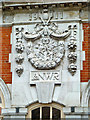
Ornament on Hatch End station building
The central part features symbolically England, Ireland and Scotland, the outer pendants are a bit of a mystery, probably something to do with harvest abundance. The whole thing bears no relation to the LNWR arms or crest. The building is grade II listed.
Image: © Robin Webster
Taken: 23 Feb 2013
0.00 miles
3
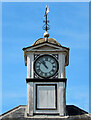
Hatch End Station - clock tower
The clock tower stands above the 1911 booking hall designed by Gerald C Horsley. The clock is showing the right time.
Image: © Stephen McKay
Taken: 23 Jul 2022
0.00 miles
4
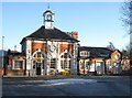
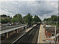
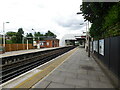
Hatch End station
Now operating under the London Overground banner. It was built by the LNWR in 1911 in a rather grand style.
Image: © Robin Webster
Taken: 23 Feb 2013
0.00 miles
7
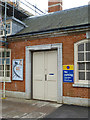
'Parcels' door, Hatch End station
In the grade II listed station building, 1911 for the LNWR. The door is now private according to the small sign.
Image: © Robin Webster
Taken: 23 Feb 2013
0.01 miles
8
Hatch End station
This entrance block is grade II listed, 1911 for the LNWR.
Image: © Robin Webster
Taken: 23 Feb 2013
0.01 miles
9
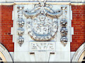
Hatch End Station - booking hall detail
Hatch End may have been no more than a mundane outer suburban station, but the London & North Western Railway spared no effort when it was rebuilt in 1911. The booking hall was designed by Gerald C Horsley and he incorporated this intricate design on the front of the building.
Image: © Stephen McKay
Taken: 23 Jul 2022
0.01 miles