IMAGES TAKEN NEAR TO
Royston Grove, PINNER, HA5 4HD
Introduction
This page details the photographs taken nearby to Royston Grove, HA5 4HD by members of the Geograph project.
The Geograph project started in 2005 with the aim of publishing, organising and preserving representative images for every square kilometre of Great Britain, Ireland and the Isle of Man.

There are currently over 7.5m images from over14,400 individuals and you can help contribute to the project by visiting https://www.geograph.org.uk
Image Map
Images are licensed for reuse under creativecommons.org/licenses/by-sa/2.0
Notes
- Clicking on the map will re-center to the selected point.
- The higher the marker number, the further away the image location is from the centre of the postcode.
Image Listing (9 Images Found)
Images are licensed for reuse under creativecommons.org/licenses/by-sa/2.0
Image
Details
Distance
1
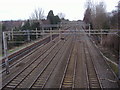
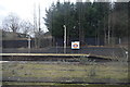
Railway lines looking to Carpenders Park
Image: © David Howard
Taken: 21 Feb 2008
0.18 miles
2
Footbridge over the West Coast Main Line, Hatch End
Image: © N Chadwick
Taken: 19 Dec 2010
0.20 miles
3
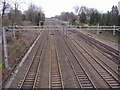
Railway lines looking towards Hatch End
Image: © David Howard
Taken: 21 Feb 2008
0.20 miles
4
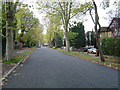
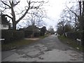
Hatch End: Royston Park Road
Viewed looking south westwards. The only hazard to life on the exclusive Royston Park housing estate is the number of learner drivers attempting reversing and three-point turns on its broad avenues.
Image: © Nigel Cox
Taken: 12 Nov 2005
0.22 miles
6
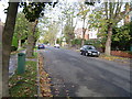
Hatch End: The Avenue
Viewed looking northwards.
Image: © Nigel Cox
Taken: 12 Nov 2005
0.23 miles
7
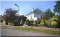
Green Tiles & Topiary
There are quite a few of these stylish deco influenced houses along here. Sherington Avenue, Hatch End.
Image: © Des Blenkinsopp
Taken: 3 Sep 2012
0.24 miles
9
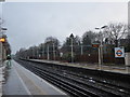
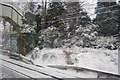
Hatch End station
The London & Birmingham Railway opened from Euston to Boxmoor in 1837 and on to Birmingham in 1838. In 1846 it became part of the London & North Western Railway.
The original station here opened as Pinner on the London & Birmingham Railway in the 1840s. It was renamed Pinner & Hatch End on 1st January 1897. The present station was built in 1911. Suburban trains were diverted from 15th June 1912 to run over the "New Lines", which had just been built between Euston and Watford Junction. The station was served by the Baker Street & Waterloo Railway (Bakerloo) from 16th April 1917, when Bakerloo services were extended from Willesden Junction to Watford Junction. The station was again renamed Hatch End (for Pinner) on 1st February 1920, and finally Hatch End on 11 June 1956. Bakerloo line services were withdrawn on 24th September 1982. The New Lines are today used by London Overground trains.
The fast lines are beyond the station to the right here. The next station in this direction is Carpenders Park. The snow of the previous Sunday was still lingering.
Image: © Marathon
Taken: 13 Dec 2017
0.24 miles