IMAGES TAKEN NEAR TO
Wynlie Gardens, PINNER, HA5 3TN
Introduction
This page details the photographs taken nearby to Wynlie Gardens, HA5 3TN by members of the Geograph project.
The Geograph project started in 2005 with the aim of publishing, organising and preserving representative images for every square kilometre of Great Britain, Ireland and the Isle of Man.

There are currently over 7.5m images from over14,400 individuals and you can help contribute to the project by visiting https://www.geograph.org.uk
Image Map
Images are licensed for reuse under creativecommons.org/licenses/by-sa/2.0
Notes
- Clicking on the map will re-center to the selected point.
- The higher the marker number, the further away the image location is from the centre of the postcode.
Image Listing (54 Images Found)
Images are licensed for reuse under creativecommons.org/licenses/by-sa/2.0
Image
Details
Distance
1
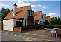
Housing on Rickmansworth Road
Interesting style of detached houses beside Wynlie Gardens, almost like bungalows with additional roof space. There are 5 in total.
Image: © Martin Addison
Taken: 12 Sep 2009
0.05 miles
2
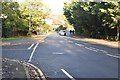
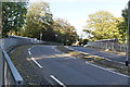
Rickmansworth Road
A rail replacement service makes its way along this straight stretch of the A404.
Image: © Martin Addison
Taken: 12 Sep 2009
0.08 miles
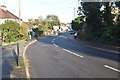
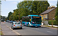
4
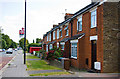
Terrace on Rickmansworth Road
A short traditional brick terrace located next to Oakcroft Close. The bus stop outside is for Crossway.
Image: © Martin Addison
Taken: 12 Sep 2009
0.10 miles