IMAGES TAKEN NEAR TO
Westbury Lodge Close, PINNER, HA5 3FG
Introduction
This page details the photographs taken nearby to Westbury Lodge Close, HA5 3FG by members of the Geograph project.
The Geograph project started in 2005 with the aim of publishing, organising and preserving representative images for every square kilometre of Great Britain, Ireland and the Isle of Man.

There are currently over 7.5m images from over14,400 individuals and you can help contribute to the project by visiting https://www.geograph.org.uk
Image Map
Images are licensed for reuse under creativecommons.org/licenses/by-sa/2.0
Notes
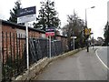
- Clicking on the map will re-center to the selected point.
- The higher the marker number, the further away the image location is from the centre of the postcode.
Image Listing (134 Images Found)
Images are licensed for reuse under creativecommons.org/licenses/by-sa/2.0
Image
Details
Distance
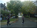
1

Houses on Westbury Lodge Close, off Chapel Lane
Three storeys trying to look like two.
Image: © Christine Johnstone
Taken: 8 Mar 2016
0.03 miles
2
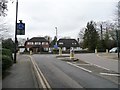
The junction of Chapel Lane and West End Lane
With a 57 metre spot height at the roundabout.
Image: © Christine Johnstone
Taken: 8 Mar 2016
0.06 miles
3
North-west corner, Pinner Memorial Park
The crocuses are out in early March.
Image: © Christine Johnstone
Taken: 8 Mar 2016
0.08 miles
4
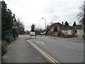
Traffic calming on West End Lane
Opposite one of the entrances to Pinner Memorial Park and just north of a primary school.
Image: © Christine Johnstone
Taken: 8 Mar 2016
0.09 miles
5
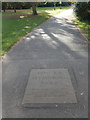
Pinner Memorial Park
Visitors to the park entering via the Chapel Lane gate pass over this slab which says 'donated by the people of Pinner in grateful memory of those who gave their lives in war and in thankfulness for all who served and fought for our liberty'.
Image: © Stephen McKay
Taken: 29 Oct 2018
0.11 miles
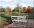
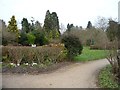
8
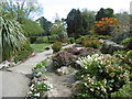
Rockery in Pinner Memorial Park
Pinner Memorial Park is on land that was part of the West House estate, at one time the home of Lord Nelson's daughter Horatia. The last owners left in 1933 and in 1934 part of the grounds were acquired by Harrow Urban District Council for public open space, initially known as Bennett's Park. Additional land was acquired in 1949 after a public campaign for a memorial to those who died in both world wars, at which time West House was also acquired, and the park was opened as Pinner Memorial Park in 1950.
A full description can be seen at http://www.londongardensonline.org.uk/gardens-online-record.asp?ID=HRW033
Image: © Marathon
Taken: 27 Apr 2016
0.11 miles
9
Promoting events, along West End Lane, Pinner
Estate agents' boards re-purposed as publicity for locally-organised events, probably as a form of sponsorship.
Image: © Christine Johnstone
Taken: 8 Mar 2016
0.11 miles