IMAGES TAKEN NEAR TO
Moss Lane, PINNER, HA5 3AP
Introduction
This page details the photographs taken nearby to Moss Lane, HA5 3AP by members of the Geograph project.
The Geograph project started in 2005 with the aim of publishing, organising and preserving representative images for every square kilometre of Great Britain, Ireland and the Isle of Man.

There are currently over 7.5m images from over14,400 individuals and you can help contribute to the project by visiting https://www.geograph.org.uk
Image Map
Images are licensed for reuse under creativecommons.org/licenses/by-sa/2.0
Notes
- Clicking on the map will re-center to the selected point.
- The higher the marker number, the further away the image location is from the centre of the postcode.
Image Listing (45 Images Found)
Images are licensed for reuse under creativecommons.org/licenses/by-sa/2.0
Image
Details
Distance
1
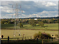
Farmland near Pinner
This stretch of green belt, currently in use for raising beef cattle belonging to Pinner Park Farm, stretches away to the north-east of Pinner.
Image: © Stephen McKay
Taken: 29 Oct 2018
0.08 miles
2
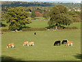
Cattle at Pinner Park Farm
There can be very little land within the old county of Middlesex still in agricultural use but here stretching away to the north east of Pinner in the Borough of Harrow is green belt land belonging to Pinner Park Farm and used for raising beef cattle. In fact the farm is owned by the council and operated on an agricultural lease by the tenants. However, the council announced proposals in 2014 to convert the land into a country park and the farm buildings - some of which are in a dilapidated condition - to residential property. This proved enormously controversial and the status quo would appear to have been maintained, at least for the time being.
Image: © Stephen McKay
Taken: 29 Oct 2018
0.14 miles
3
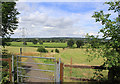
Path from Nower Hill down to Hall's Farm
A much-appreciated open area, with a path leading from the new development on Nower Hill down to George V Avenue and continuing across Hall's Farm, to the footbridge across the railway near Headstone Lane station
Image: © Patrick Wyman
Taken: 3 Aug 2012
0.16 miles
4
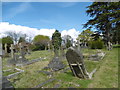
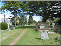
Paines Lane Cemetery
Paines Lane Cemetery opened in 1860, a modest cemetery without chapels or lodge and having a simple layout of cruciform walks. It was established here when efforts to enlarge Pinner's parish churchyard to provide burial ground for non-conformists failed. Among those buried here was Admiral Nelson's daughter Horatia. The cemetery was closed to burials in 1924.
A fuller description can be seen at http://www.londongardensonline.org.uk/gardens-online-record.asp?ID=HRW031
Image: © Marathon
Taken: 27 Apr 2016
0.19 miles
5
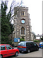
St John the Baptist, Church Lane, Pinner
Image: © John Salmon
Taken: 16 Feb 2005
0.19 miles
6
Paines Lane Cemetery
Paines Lane Cemetery opened in 1860, a modest cemetery without chapels or lodge and having a simple layout of cruciform walks. It was established here when efforts to enlarge Pinner's parish churchyard to provide burial ground for non-conformists failed. Among those buried here was Admiral Nelson's daughter Horatia. The cemetery was closed to burials in 1924.
A fuller description can be seen at http://www.londongardensonline.org.uk/gardens-online-record.asp?ID=HRW031
Image: © Marathon
Taken: 27 Apr 2016
0.19 miles
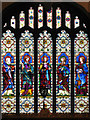
7
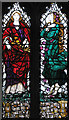
St John the Baptist, Church Lane, Pinner - Window
Designed by Louis Davis
Image: © John Salmon
Taken: 16 Feb 2005
0.20 miles
8
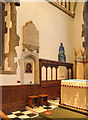
St John the Baptist, Church Lane, Pinner - Sanctuary
Image: © John Salmon
Taken: 16 Feb 2005
0.20 miles
9
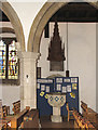
St John the Baptist, Church Lane, Pinner - Font
Image: © John Salmon
Taken: 16 Feb 2005
0.20 miles
10
St John the Baptist, Church Lane, Pinner - Window
Image: © John Salmon
Taken: 16 Feb 2005
0.20 miles