IMAGES TAKEN NEAR TO
Moss Lane, PINNER, HA5 3AG
Introduction
This page details the photographs taken nearby to Moss Lane, HA5 3AG by members of the Geograph project.
The Geograph project started in 2005 with the aim of publishing, organising and preserving representative images for every square kilometre of Great Britain, Ireland and the Isle of Man.

There are currently over 7.5m images from over14,400 individuals and you can help contribute to the project by visiting https://www.geograph.org.uk
Image Map
Images are licensed for reuse under creativecommons.org/licenses/by-sa/2.0
Notes
- Clicking on the map will re-center to the selected point.
- The higher the marker number, the further away the image location is from the centre of the postcode.
Image Listing (57 Images Found)
Images are licensed for reuse under creativecommons.org/licenses/by-sa/2.0
Image
Details
Distance
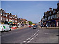
1
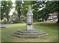
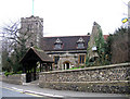
Pinner: The Tooke drinking fountain
The fountain was erected in 1886 by the inhabitants of Pinner in grateful memory of William Arthur Tooke, JP, a local dignitary. It is on a small triangular green at the junction of Church Lane and Moss Lane. With its columns of red granite and with its grey granite broach spire it is a Grade II Listed structure. Unfortunately its drinking fountain capabilites appear to have been lost for some time.
Image: © Nigel Cox
Taken: 5 Jun 2011
0.07 miles
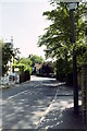
3
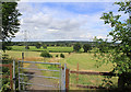
Path from Nower Hill down to Hall's Farm
A much-appreciated open area, with a path leading from the new development on Nower Hill down to George V Avenue and continuing across Hall's Farm, to the footbridge across the railway near Headstone Lane station
Image: © Patrick Wyman
Taken: 3 Aug 2012
0.10 miles
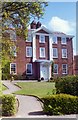
4
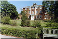
Pinner House
Sheltered housing for the elderly, the facade is a Georgian house at the back of which two modern wings have been added. Situated on Church Lane, in an area with many cases of hauntings.
Image: © Carl Grove
Taken: 22 Aug 1990
0.11 miles
6
Pinner House
A large Georgian building now used as sheltered housing for the elderly
Image: © Carl Grove
Taken: 12 Apr 1997
0.12 miles
7
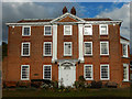
Pinner House
Pinner House on Church Lane has a façade dating from 1721 although the rest of the house was built some time earlier. It is known to have been used as a school for a time in the 19th century but later became a family home. In 1939 it became an old people's home and is now sheltered accommodation for the elderly. There are 31 self-contained flats located in a rear extension to the old house which is now used for communal area and facilities.
Image: © Stephen McKay
Taken: 29 Oct 2018
0.12 miles
8
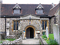
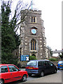
St John the Baptist, Church Lane, Pinner
Image: © John Salmon
Taken: 16 Feb 2005
0.14 miles
9
St John the Baptist, Church Lane, Pinner
Image: © John Salmon
Taken: 16 Feb 2005
0.15 miles
10
St John the Baptist, Church Lane, Pinner
Image: © John Salmon
Taken: 16 Feb 2005
0.15 miles