IMAGES TAKEN NEAR TO
Church Lane, PINNER, HA5 3AA
Introduction
This page details the photographs taken nearby to Church Lane, HA5 3AA by members of the Geograph project.
The Geograph project started in 2005 with the aim of publishing, organising and preserving representative images for every square kilometre of Great Britain, Ireland and the Isle of Man.

There are currently over 7.5m images from over14,400 individuals and you can help contribute to the project by visiting https://www.geograph.org.uk
Image Map
Images are licensed for reuse under creativecommons.org/licenses/by-sa/2.0
Notes
- Clicking on the map will re-center to the selected point.
- The higher the marker number, the further away the image location is from the centre of the postcode.
Image Listing (123 Images Found)
Images are licensed for reuse under creativecommons.org/licenses/by-sa/2.0
Image
Details
Distance
1
Pinner House
Sheltered housing for the elderly, the facade is a Georgian house at the back of which two modern wings have been added. Situated on Church Lane, in an area with many cases of hauntings.
Image: © Carl Grove
Taken: 22 Aug 1990
0.04 miles
2
Pinner House
A large Georgian building now used as sheltered housing for the elderly
Image: © Carl Grove
Taken: 12 Apr 1997
0.04 miles
5
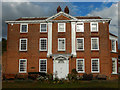
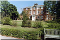
Pinner House
Pinner House on Church Lane has a façade dating from 1721 although the rest of the house was built some time earlier. It is known to have been used as a school for a time in the 19th century but later became a family home. In 1939 it became an old people's home and is now sheltered accommodation for the elderly. There are 31 self-contained flats located in a rear extension to the old house which is now used for communal area and facilities.
Image: © Stephen McKay
Taken: 29 Oct 2018
0.04 miles
6
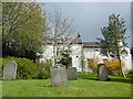
St John the Baptist Churchyard, Pinner
The battlemented west tower of St John the Baptist Church dates from the 15th century, while the body of the church dates from 1321 when it was consecrated by Bishop Petrus of Corbaria. The plan though goes back to the 13th century. The church was restored in 1880.
The most striking feature of the attractive churchyard is the Loudon Obelisk - see http://www.geograph.org.uk/photo/4928795
For more about the church and the churchyard see https://www.pinnerparishchurch.org.uk/
Image: © Marathon
Taken: 27 Apr 2016
0.08 miles
7
St John the Baptist, Pinner: churchyard
Image: © Basher Eyre
Taken: 12 Aug 2016
0.08 miles
8
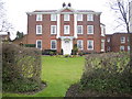
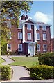
Pinner House
The house is in Church Lane and is possibly 17th century with the façade being completed in 1721. Between 1788 and 1811 it was the home of the Rev. Walter Williams, Vicar of Pinner and Harrow, and his wife, Mary Beauclerc, great-granddaughter of King Charles II and Nell Gwynn.
Image: © Nigel Cox
Taken: 23 Mar 2007
0.08 miles
9
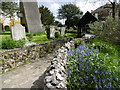
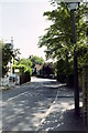
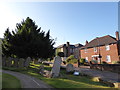
The path to the lych gate, St John the Baptist Churchyard, Pinner
The battlemented west tower of St John the Baptist Church dates from the 15th century, while the body of the church dates from 1321 when it was consecrated by Bishop Petrus of Corbaria. The plan though goes back to the 13th century. The church was restored in 1880.
The obelisk on the left of the path was erected by John Claudius Loudon in 1843 to his parents. It consists of an arch cut in on each side at the foot, and higher up two ends of a fake coffin sticking out at the front and back. The tomb is known as “the coffin above the ground”. Loudon was a Victorian horticulturalist who came down from Scotland. He brought his parents from Scotland to help him manage Wood Hall Farm which he had bought in 1807. Loudon wrote 32 books and over four million words on horticulture and architecture. He introduced the plane tree to London squares, suggested green belts around towns, and laid out cemeteries and public parks. He made a fortune and lost it, dying “harassed by creditors”. His wife Amelia was the author of ‘The Ladies Flower Garden’.
For more about the church and the churchyard see https://www.pinnerparishchurch.org.uk/
Image: © Marathon
Taken: 27 Apr 2016
0.08 miles
10
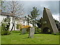
Pinner Churchyard and "the coffin above the ground"
The battlemented west tower of St John the Baptist Church dates from the 15th century, while the body of the church dates from 1321 when it was consecrated by Bishop Petrus of Corbaria. The plan though goes back to the 13th century. The church was restored in 1880.
The obelisk seen here is the best-known and most prominent object in the attractive churchyard. It was erected by John Claudius Loudon in 1843 to his parents. It consists of an arch cut in on each side at the foot, and higher up two ends of a fake coffin sticking out at the front and back. The tomb is known as “the coffin above the ground”. Loudon was a Victorian horticulturalist who came down from Scotland. He brought his parents from Scotland to help him manage Wood Hall Farm which he had bought in 1807. Loudon wrote 32 books and over four million words on horticulture and architecture. He introduced the plane tree to London squares, suggested green belts around towns, and laid out cemeteries and public parks. He made a fortune and lost it, dying “harassed by creditors”. His wife Amelia was the author of ‘The Ladies Flower Garden’.
For more about the church and the churchyard see https://www.pinnerparishchurch.org.uk/
Image: © Marathon
Taken: 27 Apr 2016
0.09 miles