IMAGES TAKEN NEAR TO
Haydon Drive, PINNER, HA5 2PW
Introduction
This page details the photographs taken nearby to Haydon Drive, HA5 2PW by members of the Geograph project.
The Geograph project started in 2005 with the aim of publishing, organising and preserving representative images for every square kilometre of Great Britain, Ireland and the Isle of Man.

There are currently over 7.5m images from over14,400 individuals and you can help contribute to the project by visiting https://www.geograph.org.uk
Image Map
Images are licensed for reuse under creativecommons.org/licenses/by-sa/2.0
Notes
- Clicking on the map will re-center to the selected point.
- The higher the marker number, the further away the image location is from the centre of the postcode.
Image Listing (24 Images Found)
Images are licensed for reuse under creativecommons.org/licenses/by-sa/2.0
Image
Details
Distance

3
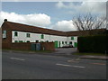
Joel Street Farm
Did belong to Robarts. My Father worked there as a Cowman in 1930's
Image: © pearl gardner
Taken: 16 Mar 2002
0.03 miles

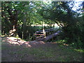
7
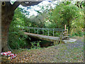
Concrete footbridge
On the footpath from Joel Street to Catlin's Lane.
Image: © Robin Webster
Taken: 29 Sep 2012
0.11 miles