IMAGES TAKEN NEAR TO
Joel Street, PINNER, HA5 2PA
Introduction
This page details the photographs taken nearby to Joel Street, HA5 2PA by members of the Geograph project.
The Geograph project started in 2005 with the aim of publishing, organising and preserving representative images for every square kilometre of Great Britain, Ireland and the Isle of Man.

There are currently over 7.5m images from over14,400 individuals and you can help contribute to the project by visiting https://www.geograph.org.uk
Image Map
Images are licensed for reuse under creativecommons.org/licenses/by-sa/2.0
Notes
- Clicking on the map will re-center to the selected point.
- The higher the marker number, the further away the image location is from the centre of the postcode.
Image Listing (79 Images Found)
Images are licensed for reuse under creativecommons.org/licenses/by-sa/2.0
Image
Details
Distance
5
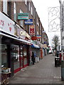
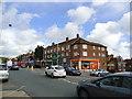
Northwood Hills: Ryefield Parade
One of countless similar parades of shops in outer London, this one is in Joel Street and includes Northwood Hills Post Office.
Image: © Chris Downer
Taken: 10 Jan 2011
0.05 miles
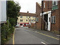
6
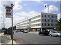
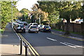
Outside Northwood Hills Station (S)
Looking south along Joel Street.
Image: © Des Blenkinsopp
Taken: 28 Jun 2014
0.05 miles
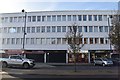
10

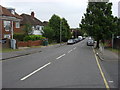
Shops on Joel Street, Northwood Hills
The tube station is on the left of the same name as the district.
Image: © David Howard
Taken: 2 Dec 2015
0.06 miles