IMAGES TAKEN NEAR TO
Salisbury Road, PINNER, HA5 2NN
Introduction
This page details the photographs taken nearby to Salisbury Road, HA5 2NN by members of the Geograph project.
The Geograph project started in 2005 with the aim of publishing, organising and preserving representative images for every square kilometre of Great Britain, Ireland and the Isle of Man.

There are currently over 7.5m images from over14,400 individuals and you can help contribute to the project by visiting https://www.geograph.org.uk
Image Map
Images are licensed for reuse under creativecommons.org/licenses/by-sa/2.0
Notes
- Clicking on the map will re-center to the selected point.
- The higher the marker number, the further away the image location is from the centre of the postcode.
Image Listing (41 Images Found)
Images are licensed for reuse under creativecommons.org/licenses/by-sa/2.0
Image
Details
Distance
1
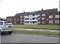
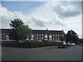
Block of flats on Salisbury Road, Northwood Hills
Image: © David Howard
Taken: 17 Jul 2014
0.02 miles
2
Block of flats on Salisbury Road, Northwood Hills
Compare with my slightly earlier view http://www.geograph.org.uk/photo/4076944
Image: © David Howard
Taken: 2 Dec 2015
0.02 miles
3
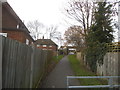
Path between Salisbury Road and Malmesbury Close
Image: © David Howard
Taken: 2 Dec 2015
0.02 miles
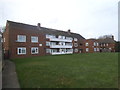
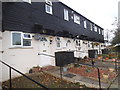
4

Fairacres on Salisbury Road, Northwood Hills
Image: © David Howard
Taken: 2 Dec 2015
0.04 miles
6
Shops on Salisbury Road, Northwood Hills
Image: © David Howard
Taken: 17 Jul 2014
0.05 miles
7
Shops on Salisbury Road, Northwood Hills
Image: © David Howard
Taken: 2 Dec 2015
0.05 miles
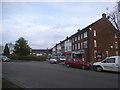
8
Row of houses on Salisbury Road, Northwood Hills
Image: © David Howard
Taken: 2 Dec 2015
0.06 miles
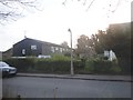
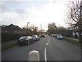
10

Concrete lamppost on Wiltshire Lane
These are the local design, many still not replaced with the new versions
Image: © David Howard
Taken: 2 Dec 2015
0.07 miles