IMAGES TAKEN NEAR TO
Catlins Lane, PINNER, HA5 2EZ
Introduction
This page details the photographs taken nearby to Catlins Lane, HA5 2EZ by members of the Geograph project.
The Geograph project started in 2005 with the aim of publishing, organising and preserving representative images for every square kilometre of Great Britain, Ireland and the Isle of Man.

There are currently over 7.5m images from over14,400 individuals and you can help contribute to the project by visiting https://www.geograph.org.uk
Image Map
Images are licensed for reuse under creativecommons.org/licenses/by-sa/2.0
Notes
- Clicking on the map will re-center to the selected point.
- The higher the marker number, the further away the image location is from the centre of the postcode.
Image Listing (24 Images Found)
Images are licensed for reuse under creativecommons.org/licenses/by-sa/2.0
Image
Details
Distance
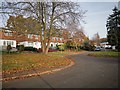
5
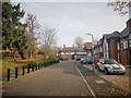
Pinner - High Meadow Close
Mordern housing development off Daymer Gardens.
Image: © James Emmans
Taken: 20 Nov 2019
0.11 miles
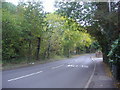
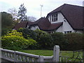
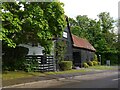
7
The Grange, Eastcote High Road
There is quite a huddle of old farm buildings here, now converted for residential and business use.
Image: © Stefan Czapski
Taken: 5 May 2022
0.12 miles
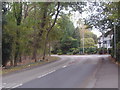
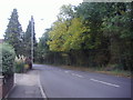
8
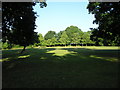
Cuckoo Hill
Early morning in this recreational area.
Image: © Marion Phillips
Taken: 3 Jun 2011
0.12 miles
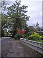
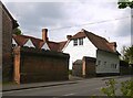
9
The Grange Barn, Pikes End, Eastcote High Road
Image: © Stefan Czapski
Taken: 5 May 2022
0.12 miles