IMAGES TAKEN NEAR TO
Azalea Walk, PINNER, HA5 2EH
Introduction
This page details the photographs taken nearby to Azalea Walk, HA5 2EH by members of the Geograph project.
The Geograph project started in 2005 with the aim of publishing, organising and preserving representative images for every square kilometre of Great Britain, Ireland and the Isle of Man.

There are currently over 7.5m images from over14,400 individuals and you can help contribute to the project by visiting https://www.geograph.org.uk
Image Map
Images are licensed for reuse under creativecommons.org/licenses/by-sa/2.0
Notes
- Clicking on the map will re-center to the selected point.
- The higher the marker number, the further away the image location is from the centre of the postcode.
Image Listing (30 Images Found)
Images are licensed for reuse under creativecommons.org/licenses/by-sa/2.0
Image
Details
Distance
1
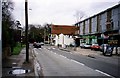
Black Horse Parade, Eastcote Village
Image: © Nick Mutton 01329 000000
Taken: 26 Dec 1997
0.07 miles

3
Georgian Lodge, Bridle Road, Eastcote
Looking south across Bridle Road
Image: © David Hawgood
Taken: 3 Jan 2006
0.08 miles
4
Along the Celandine Route in Eastcote
The Celandine Route follows the River Pinn between Pinner and Uxbridge. This is beside Eastcote High Road.
Image: © Des Blenkinsopp
Taken: 13 Nov 2018
0.10 miles
5
Path to the river Pinn
This view is from High Road Eastcote. The path on the left crosses the River Pinn just ahead. The River Pinn is a tributary of the Frays River which it joins at Yiewsley after passing through Ickenham and Uxbridge.
Image: © Marathon
Taken: 31 Jan 2018
0.10 miles
7
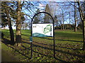
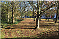
Eastcote House Gardens
Eastcote House stood in these gardens from around 1507 until it was demolished in 1964. It was the principal residence of the Hawtrey Deane family. All that remains of its many outbuildings and grounds are the stables, dovecote, walled garden, ha-ha and many fine trees.
Ruislip-Northwood Urban District Council purchased the house and grounds in 1931 after it became endangered by a proposed new housing development. Sadly, under the ownership of the Council, the condition of the house deteriorated and in 1962 the house was declared unsafe, and it was demolished two years later after the Council ruled there were no features of the house worth retaining!
A full history can be seen at https://en.wikipedia.org/wiki/Eastcote_House_Gardens
Image: © Marathon
Taken: 31 Jan 2018
0.13 miles
8
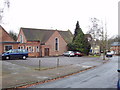
Eastcote Methodist Church
Taken from Pamela Gardens. There has been a Methodist congregation in Eastcote since 1825, this church was completed in 1962. See http://www.hah.org.uk/eastcote/eastcote.htm on Harrow and Hillingdon Circuit website for more information.
Image: © David Hawgood
Taken: 3 Jan 2006
0.16 miles
9
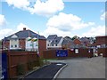
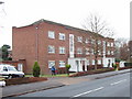
Housing on former RAF Eastcote site
Housing under construction on the former RAF Eastcote site. RAF Eastcote housed several codebreaking machines from Bletchley Park during the Second World War which became the precursor to GCHQ.
Image: © Ian Harrison
Taken: 11 Jun 2011
0.17 miles
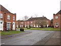
10
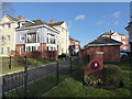
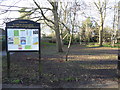
The entrance to Pembroke Park
The new housing development of Pembroke Park takes its name from the Second World War base HMS Pembroke V. From 1943 to 1945 it was an outstation of the Government Code and Cipher School (GC & CS) at Bletchley Park and as such played a significant role in deciphering enemy signals. The site was home to 800 Wrens who worked on 110 ‘bombes’ electro-mechanical decoding machines with the support of 100 RAF technicians.
After the War, (GC & CS) changed its name to Government Communications Headquarters (GCHQ) and moved to this site. It remained here until the relocation of most of its functions to Cheltenham in the early 1950s. A small unit remained at Eastcote until the late 1970s. The names of the roads and some of the buildings in Pembroke Park were chosen to reflect the history of the site.
This is the view from the entrance off Eastcote Road. The information here is taken from a memorial plaque on the brick structure in the foreground with the wreath of poppies on it.
Image: © Marathon
Taken: 31 Jan 2018
0.18 miles