IMAGES TAKEN NEAR TO
Raisins Hill, PINNER, HA5 2BT
Introduction
This page details the photographs taken nearby to Raisins Hill, HA5 2BT by members of the Geograph project.
The Geograph project started in 2005 with the aim of publishing, organising and preserving representative images for every square kilometre of Great Britain, Ireland and the Isle of Man.

There are currently over 7.5m images from over14,400 individuals and you can help contribute to the project by visiting https://www.geograph.org.uk
Image Map
Images are licensed for reuse under creativecommons.org/licenses/by-sa/2.0
Notes
- Clicking on the map will re-center to the selected point.
- The higher the marker number, the further away the image location is from the centre of the postcode.
Image Listing (27 Images Found)
Images are licensed for reuse under creativecommons.org/licenses/by-sa/2.0
Image
Details
Distance
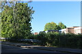
1
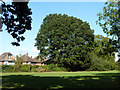
Oak tree, Pinner
In the small open space on Cuckoo Hill.
Image: © Robin Webster
Taken: 29 Sep 2012
0.10 miles
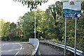
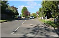
3
Cuckoo Hill looking towards Nursery Road, Pinner
Image: © David Howard
Taken: 30 May 2021
0.14 miles
4
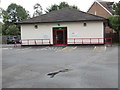
Pinner Driving Test Centre
Located at 221 Tolcarne Drive, HA5 2DZ this Centre carries out practical driving tests for cars. The notice on the left of the entrance says "This car park is for the use of test candidates only. No bay parking practicing allowed in this car park at any time".
Image: © David Hillas
Taken: 5 Sep 2015
0.15 miles
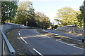
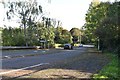
8
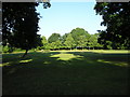
Cuckoo Hill
Early morning in this recreational area.
Image: © Marion Phillips
Taken: 3 Jun 2011
0.16 miles