IMAGES TAKEN NEAR TO
The Close, PINNER, HA5 1PH
Introduction
This page details the photographs taken nearby to The Close, HA5 1PH by members of the Geograph project.
The Geograph project started in 2005 with the aim of publishing, organising and preserving representative images for every square kilometre of Great Britain, Ireland and the Isle of Man.

There are currently over 7.5m images from over14,400 individuals and you can help contribute to the project by visiting https://www.geograph.org.uk
Image Map
Images are licensed for reuse under creativecommons.org/licenses/by-sa/2.0
Notes
- Clicking on the map will re-center to the selected point.
- The higher the marker number, the further away the image location is from the centre of the postcode.
Image Listing (65 Images Found)
Images are licensed for reuse under creativecommons.org/licenses/by-sa/2.0
Image
Details
Distance
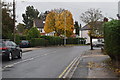
4
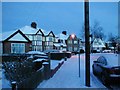
Boldmere Road in the snow
It snowed in the night and it is still all clean before the cars churn it up.
Image: © Rhys James
Taken: 31 Jan 2003
0.09 miles
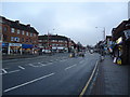
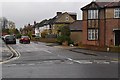
6

Santander Bank Branch in Eastcote
This photo shows the Santander branch at 137 Field End Road, the postcode being HA5 1QN. It is due to close permanently on Thursday 25th April 2019.
Image: © David Hillas
Taken: 4 Apr 2019
0.09 miles
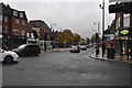
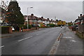
9
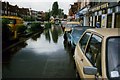
Field End Road
This was taken after a period of heavy rain in 1984.
Image: © Nick Mutton 01329 000000
Taken: 1 Oct 1984
0.10 miles